Weather
Tropical Storm Hermine's Expected Impact on Connecticut for Sunday, Labor Day: Latest Update
The National Weather Service has issued a Tropical Storm Warning for parts of Connecticut and a Hazardous Weather Outlook for the rest.

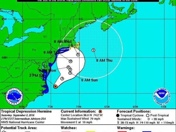
Tropical Storm Hermine is slowly moving up the East Coast and Connecticut should begin to see some of the effects of the powerful storm later on Sunday and Labor Day. (For continued updates on the storm, including news on power outages and road closures, sign up for Patch news alerts here.)
The Connecticut coastline from Greenwich to New London will see the greatest impacts from this storm. A Tropical Storm Warning has been issued for areas along the immediate coast.
Interior sections of Fairfield, New Haven, Middlesex, New London, along with Hartford and Tolland counties will see less effects from Hermine and are under a Hazardous Weather Outlook.
Find out what's happening in Darienfor free with the latest updates from Patch.
Hermine’s impact on Connecticut isn’t going to be a major rainstorm. The immediate coast may see up to an inch of rain total, and areas inland may see a half inch of rain, according to the current projections from the National Weather Service.
The real concern in Connecticut, especially at the coast, is the wind and storm surge which may result in moderate to severe coastal flooding later on Sunday. On the coast, winds will gust 20 to 30 mph and possibly up to 50 mph, the weather service states.
Find out what's happening in Darienfor free with the latest updates from Patch.
The storm surge at the coast may be 2-4 feet above ground beginning early Sunday afternoon, the weather service states. Damage to buildings near the coast is possible, the weather service states. There could be damage to marinas, docks, boardwalks, and piers too.
In interior sections, some showers are possible and gusty winds at times but the major effects are more likely at the immediate coast.
Governor Dannel P. Malloy is continuing to caution shoreline residents about possible flooding from Tropical Storm Hermine, especially those in low-lying, flood prone areas as tropical storm warnings have been issued for the immediate Connecticut coast.
In addition, all Connecticut state park campgrounds will close at noon on Sunday, Sept. 4 due to the anticipated conditions.
The Governor will also partially activate the state Emergency Operations Center in Hartford beginning at 6 p.m. on Sunday.
"After assessing the current forecast with emergency management officials, I have decided to partially activate the state emergency operations center on Sunday evening to monitor conditions across the state. This will also allow us to better coordinate any assistance to our municipalities that may be necessary," Governor Malloy said in a news release. "If you live in a low-lying, flood prone area, please stay alert to changing weather conditions, especially during high tide cycles over the next few days."
Hermine continues to move into the Atlantic off the Mid Atlantic Coast. The storm will then turn north and regain strength on Sunday and stall off the coast Sunday night into Monday before resuming a slow northeast track southeast of Long Island Tuesday into Wednesday, the National Weather Service states.
Here’s the latest on what we can expect in Connecticut:
Weather forecast for coastal Connecticut:
Sunday: 20 percent chance of rain after 2 p.m. Mostly cloudy with a high near 76. Winds up to 24 mph.
Sunday night: 50 percent chance of rain. Winds gusting up to 44 mph.
Labor Day: Rain expected. Temps near 75 degrees. Winds gusting up to near 50 mph.
Monday night: 50 percent chance of rain.
Interior sections of southern Connecticut:
Sunday: 20 percent chance of rain after 2 p.m. Partly sunny and temps near 76 degrees. Winds gusting between 12 to 17 mph.
Sunday night: 40 percent chance of rain and winds gusting up to 23 mph.
Labor Day: Tropical storm conditions possible. Rain likely and winds gusting up to 24 mph.
Monday night: 50 percent chance of rain.
Hartford and Tolland counties:
Sunday: Partly sunny, high near 74.
Sunday night: Tropical storm conditions possible. A chance of showers after 3 a.m. Winds gusting up to 22 mph.
Labor Day: Tropical storm conditions possible. A chance of showers, with thunderstorms also possible after 2 p.m. Cloudy with a high near 72. Winds gusting up to 26 mph.
Monday night: A chance of showers and thunderstorms.
Image via the National Weather Service
Get more local news delivered straight to your inbox. Sign up for free Patch newsletters and alerts.


