Weather
Another Nor'easter May Impact CT Next Week
Could Connecticut see its third nor'eastern in three weeks? It is possible and something meteorologists are keeping a close eye on.


The National Weather Service is urging anyone that has to travel today to be very careful as more than a foot of snow fell in many places in Connecticut. Numerous roads are blocked by downed trees and power lines that fell under the weight of the heavy snow. More than 100,000 Connecticut residents are without power this morning.
Over the past two weeks Connecticut has dealt with two nor'easters and don't look now but another potential major storm may impact us early next week. The National Weather Service says there is a 40-50 percent chance of snow developing on Monday afternoon, changing to rain, and then back to snow on Tuesday. Again, that storm is several days away and no one will know what it can mean for us until we get closer to that date.
WTNH News 8 Meteorologist Gil Simmons said he is keeping a close eye on Monday-Tuesday AM for "another close storm." In an Instagram post, Simmons urged residents to be careful while shoveling as the snow is very heavy.
Find out what's happening in Greenwichfor free with the latest updates from Patch.
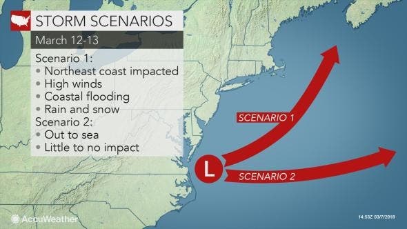
Accuweather.com says the potential storm on Monday/Tuesday may go out to sea or it could strengthen and hit us with another nor'easter.
"During early next week, the storm will reach the southern Atlantic coast and may continue to head eastward and well out to sea or may reorganize, strengthen and turn northward," according to AccuWeather Senior Meteorologist Dan Pydynowski.
Find out what's happening in Greenwichfor free with the latest updates from Patch.
Accuweather adds that if the storm heads out to sea then we will feel no impact but if it turns northward "it might mean another nor'easter with strong winds and heavy rain and/or snow."
While we wait to see what might happen early next week, the good news is that it appears pretty quiet for the next few days with sunny skies and temps in the 40s.
I’m not complaining because so many people have it far worse, but a tree came crashing down on our house from the Nor’easter #WinterStormElsa Thankfully no damage. Full storm coverage at noon on @WFSBnews with @karasundlun pic.twitter.com/FLaxJkHz1Z
— Dennis House (@DennisHouseTV) March 8, 2018
As expected that was a wild storm. Came home to 10” or compacted paste. Tons of power outages and trees down. Worked about as forecast except the narrow megaband in some of the W CT hilltowns with 2ft or so.
— Ryan Hanrahan (@ryanhanrahan) March 8, 2018
Bethany CT pic.twitter.com/h7xbXbgyHk
— Chudsy (@mrbelaker1) March 8, 2018
From a close friend in Higganum. His property. This is what our town looks like all over. It’s pretty but so destructive! #StormHour pic.twitter.com/ca0UmCjkCF
— eweather (@Eweather13) March 8, 2018
Here is the updated weather forecast for the Connecticut coast:
Today: Partly sunny, with a high near 43. Wind chill values between 25 and 35. West wind 10 to 14 mph.
Tonight: Mostly cloudy, with a low around 25. West wind 6 to 9 mph.
Friday: Mostly cloudy, with a high near 41. Wind chill values between 20 and 30. West wind 8 to 13 mph.
Friday Night: Mostly cloudy, with a low around 30. West wind around 9 mph.
Saturday: Mostly sunny, with a high near 44. West wind 9 to 15 mph.
Saturday Night: Mostly clear, with a low around 29.
Sunday: Sunny, with a high near 43.
Sunday Night: Mostly cloudy, with a low around 31.
Monday: A chance of snow before noon, then a chance of rain. Mostly cloudy, with a high near 42. Chance of precipitation is 40%.
Monday Night: A chance of rain before midnight, then a chance of snow. Mostly cloudy, with a low around 32. Chance of precipitation is 30%.
Here is the updated weather forecast for inland sections of Southern Connecticut:
Today: Partly sunny, with a high near 43. Wind chill values between 25 and 35. West wind 8 to 11 mph.
Tonight: Mostly cloudy, with a low around 24. West wind 3 to 7 mph.
Friday: A slight chance of rain and snow showers after noon. Mostly cloudy, with a high near 41. Wind chill values between 20 and 30. West wind 6 to 10 mph, with gusts as high as 20 mph. Chance of precipitation is 20%.
Friday Night: Mostly cloudy, with a low around 27. West wind around 6 mph.
Saturday: Mostly sunny, with a high near 44. West wind 6 to 13 mph.
Saturday Night: Mostly clear, with a low around 27.
Sunday: Sunny, with a high near 43.
Sunday Night: Mostly cloudy, with a low around 30.
Monday: A chance of snow before noon, then a chance of rain. Mostly cloudy, with a high near 42. Chance of precipitation is 40%.
Monday Night: A chance of rain before midnight, then a chance of snow. Mostly cloudy, with a low around 31. Chance of precipitation is 40%.
Today: A chance of snow, mainly before 9am. Mostly cloudy, with a high near 40. Northwest wind around 8 mph. Chance of precipitation is 30%. Total daytime snow accumulation of less than one inch possible.
Tonight: Partly cloudy, with a low around 27. West wind 3 to 6 mph.
Friday: A slight chance of snow showers between noon and 1pm, then a slight chance of rain showers after 1pm. Increasing clouds, with a high near 40. Southwest wind 3 to 8 mph. Chance of precipitation is 20%.
Friday Night: Mostly cloudy, with a low around 29. West wind around 7 mph.
Saturday: Partly sunny, with a high near 42. West wind 6 to 10 mph, with gusts as high as 22 mph.
Saturday Night: Mostly clear, with a low around 27.
Sunday: Sunny, with a high near 44.
Sunday Night: Mostly cloudy, with a low around 30.
Monday: A chance of snow between 9am and noon, then a chance of rain after noon. Mostly cloudy, with a high near 41. Chance of precipitation is 40%.
Monday Night: A chance of rain before 9pm, then a chance of snow. Mostly cloudy, with a low around 30. Chance of precipitation is 50%.
Tuesday: A chance of rain and snow. Mostly cloudy, with a high near 41. Chance of precipitation is 40%.
Transformer blew up and lighting up the night sky over Route 10 in Hamden! #nbcct @ryanhanrahan @WeatherJosh @KaitMcGrathNBC pic.twitter.com/XdkbDZp7Xl
— Noah Bergren (@NbergWX) March 8, 2018
Get more local news delivered straight to your inbox. Sign up for free Patch newsletters and alerts.