Weather
Hazardous Weather Outlook Dropped for Connecticut in Connection to Hurricane Matthew
Attention once again turns to Connecticut's current severe drought status.

In two days a lot has changed concerning Hurricane Matthew and its possible impact on Connecticut. On Tuesday, meteorologists were worried that Connecticut could be greatly impacted by the powerful storm, and by Wednesday it appeared the storm would have minimal, if any, impact on the state.
And on Thursday, the latest track reveals that Matthew will offer no impact to Connecticut’s weekend weather forecast after all.
The National Weather Service officially dropped its Hazardous Weather Outlook for Connecticut, which had been in effect through Wednesday. Now we’re looking at a relatively quiet weekend forecast with some sun and clouds. Sunday's forecast is looking better than Saturday's right now.
Find out what's happening in Greenwichfor free with the latest updates from Patch.
And of course this is great news for us in Connecticut that the hurricane won’t impact us at all, but concerns will intensify about the severe drought conditions in Connecticut.
There isn’t a significant rain chance over the next seven days, according to the latest National Weather Service forecast. (See below for CT's weekend forecast).
Find out what's happening in Greenwichfor free with the latest updates from Patch.
WTNH News 8 meteorologist Gil Simmons wrote on Facebook Thursday morning that “I'm expecting a great weather day today with sunshine and temperatures in the 70s. More of the same with warmer temps for tomorrow! A quick rain shower in a couple of spots Saturday, but not much. Back to quiet weather for Sunday and Monday!
“We are also watching Hurricane Matthew and this will be a major impact to the East Coast of Florida and to some extent Georgia and South Carolina. My thoughts and prayers with everyone down in Florida Georgia and South Carolina,” Simmons added.
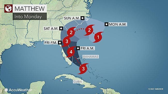
Hurricane Matthew was approaching Andros Island in the Bahamas Thursday morning as its outer bands neared Florida’s east coast. With powerful maximum sustained winds of 125 mph, the system was a strong Category 3 storm that the National Hurricane Center expects will gain more strength as the day moves on.
As of the hurricane center's 8 a.m. Oct. 6 update, Matthew was positioned about 30 miles south-southwest of Nassau, Bahamas. The system was moving northwest at 12 mph.
“Additional strengthening is expected today, and Matthew is forecast to be a Category 4 hurricane as it approaches the east coast of Florida,” the hurricane center’s report said. Hurricane-force winds extended out up to 40 miles Thursday morning. Tropical-storm force winds extended out 160 miles, forecasters said.
On its current projected path, Matthew could make landfall somewhere along Florida’s east coast as a major hurricane. While the storm's outer bands were arriving near Florida Thursday morning, forecasters do not expect it to clear the Sunshine State until late Friday night.
Here’s a look at the updated weekend forecast for Connecticut via the National Weather Service:
Thursday: Sunshine, temps in the low 70s.
Friday: Sunshine, temps in the low 70s.
Saturday: Mostly cloudy with a slight chance of a shower or two. Temps in the upper 60s.
Sunday: Mostly sunny, temps in the mid 60s.
Again no real rain in the forecast through next Wednesday.
Reporting by Sherri Lonon and Brian McCready, Patch Staff
Photo credit: Accuweather.com
Get more local news delivered straight to your inbox. Sign up for free Patch newsletters and alerts.