Weather
‘Significant’ Storm Update for Connecticut
We have the latest details on the 'big storm' expected this week and accumulating snow is now possible Thursday too.


The forecast for Tuesday’s significant storm continues to call for a period of icing for most of Connecticut before a changeover to a heavy rain Tuesday afternoon lasting into Wednesday morning. It appears unlikely that any areas of the state will see snow accumulation from this storm, but there could be a few hours of icing in inland areas, which could cause slippery travel conditions.
On the immediate coast, it’s just plain rain for this storm. While Tuesday and Wednesday’s storm won’t yield any snow, there is now a chance that a storm originally thought to stay away from Connecticut may now bring some snow to the state. But meteorologists say Thursday’s snow chance bears close watching but it’s still unclear whether it will actually occur.
NBC Connecticut Meteorologist Ryan Hanrahan said “Here's the deal with Tuesday/Wednesday.... a bit of wintry mix on Tuesday with some icing especially in the hills. It may be slick for a bit on Tuesday before we go over to rain on Wednesday. Wednesday looks very mild! Beyond that there's a chance we could see a follow up wave with some snow on Thursday - we'll have to watch this closely. This is a really convoluted and complex storm with a lot of moving pieces. We'll keep you posted.”
Find out what's happening in Greenwichfor free with the latest updates from Patch.
Hanrahan said he doubts Tuesday will be a snow day for students and teachers in Connecticut.
WTNH News 8 Meteorologist Kevin Arnone wrote on News 8 that the precipitation begins Tuesday morning and he believes the mixed precipitation lasts a “few hours” inland. He said he thinks the mixed-precipitation will only accumulate lightly.
Find out what's happening in Greenwichfor free with the latest updates from Patch.
“Really not much at this point, but heads up for an icy spot or two. School issues are not likely,” Arnone wrote. “Rain will continue Tuesday evening into early Wednesday before drying out midday with 1-2 inches of rain expected when all is said and done.”
As for Thursdays snow, he said two models now show “plowable snow” in Connecticut Thursday morning into the afternoon, but he stressed that the track could definitely change.
The National Weather Service Sunday night issued a "Hazardous Weather Outlook" for Hartford and Tolland counties for Tuesday as snow will quickly change to sleet and freezing rain in the morning, and could last into the afternoon. A slippery commute is possible in Hartford and Tolland counties in the morning.
Here’s the latest updates via the National Weather Service concerning the mid week storm:
Monday night: On the immediate coast, some rain and sleet between 1 a.m. and 2 a.m. and then it’s all rain after 2 a.m. Rain continues all day Tuesday, high near 42 degrees. More rain Tuesday night and the rain should be over by 7 a.m. Wednesday.
A chance of snow on the coast after midnight Wednesday into Thursday morning.
Inland areas of southern Connecticut:
Monday night: Chance of snow, freezing rain and sleet between 1 a.m. and 4 a.m. and then some freezing rain and sleet likely. Little or no ice accumulation expected. It’s all plain rain after 8 a.m. Tuesday with a high near 40 degrees. Heavy rain Tuesday night and it moves out by 7 a.m.
A chance of snow after midnight Wednesday into Thursday morning.
Northern Connecticut:
Monday night: Snow likely after 4 a.m. Tuesday and snow and sleet up until 11 a.m. and then a change to plain rain after noon Tuesday. Rain Tuesday night and it ends around 10 a.m. Wednesday.
You can read Kevin Arnone’s full forecast details here at WTNH News 8.
You can check out the NBC Connecticut weather team's forecast here.
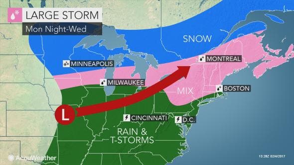
Image via Accuweather.com
Get more local news delivered straight to your inbox. Sign up for free Patch newsletters and alerts.


