Weather
Tropical Storm Michael Could Bring Downpours To CT
The storm is expected to strengthen to a hurricane and strike the Gulf Coast this week.

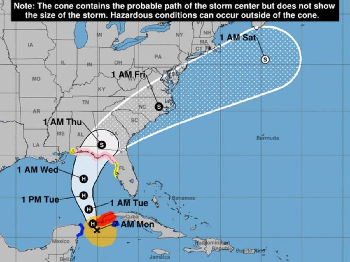
CONNECTICUT — Another hurricane could bring more nasty rainfall to Connecticut this week after striking the Gulf Coast, forecasters say. Tropical Storm Michael was just off the coast of Cuba Monday morning as it headed for the southeastern U.S., according to the National Hurricane Center.
Michael is expected to strenghten into a Category 2 hurricane before making landfall along Florida or Alabama in the middle of this week, AccuWeather senior meteorologist Kristina Pydynowski writes.
The storm will track toward the Northeast amid unusually warm weather in Connecticut — Wednesday's high in Connecticut will near 80 degrees, well above the normal level of 66, according to the National Weather Service.
Find out what's happening in Greenwichfor free with the latest updates from Patch.
While Michael won't directly hit Connecticut, it's expected to bring a fair amount of rain to the area — up to 2 inches, according to the National Hurricane Center's latest projection. The weather service says to expect showers and thunderstorms on Thursday.

The exact impact will depend on the storm's track and the speed of the cold front expected to move into the region later in the week, Pydynowski writes.
Find out what's happening in Greenwichfor free with the latest updates from Patch.
"There is also concern that the front and Michael will slow their forward speed, which can lead to more significant flooding over not just a part of the South but the Northeast," AccuWeather senior meteorologist Alan Reppert told the site.
Michael could drench Connecticut less than a month after the remnants of Hurricane Florence flooded the state.
On the bright side, Connecticut is expected to feel more like fall once the storm passes. The mercury will reach a crisp high near 65 on Friday before an even cooler high near 59 on Saturday, according to the National Weather Service.
What's left of Michael will race northeast after landfall. How close it comes to Connecticut will determine how much rain we see later this week. Low risk for excessive rain/flood issues. #nbcct pic.twitter.com/AN70DyJznR
— Ryan Hanrahan (@ryanhanrahan) October 8, 2018
A good way at looking at possible rainfall from Michael is this plume diagram off the GFS ensembles showing possible scenarios. Most likely is a moderate rainfall - but there are a few outliers that would mean much heavier rain is possible. #nbcct pic.twitter.com/ycfJYk8unl
— Ryan Hanrahan (@ryanhanrahan) October 8, 2018
Here's a closer look at what to expect from this week's wet weather, courtesy of the National Weather Service.
Columbus Day
Patchy drizzle. Cloudy, with a high near 67. East wind around 10 mph.
Tonight
Patchy drizzle. Areas of fog. Otherwise, cloudy, with a low around 61. East wind 6 to 8 mph.
Tuesday
Patchy drizzle before 11am. Areas of fog before 11am. Otherwise, mostly cloudy, with a high near 75. Southwest wind 6 to 8 mph.
Tuesday Night
Mostly cloudy, with a low around 65. Southwest wind around 6 mph.
Wednesday
Partly sunny, with a high near 79. Southwest wind 5 to 7 mph.
Wednesday Night
Mostly cloudy, with a low around 69.
Thursday
A chance of showers, then showers and possibly a thunderstorm after noon. High near 74. Chance of precipitation is 80%.
Thursday Night
Showers likely and possibly a thunderstorm before midnight, then a chance of showers. Mostly cloudy, with a low around 58. Chance of precipitation is 70%.
Friday
A 30 percent chance of showers before noon. Partly sunny, with a high near 65.
Friday Night
Partly cloudy, with a low around 49.
Saturday
Mostly sunny, with a high near 58.
Saturday Night
Partly cloudy, with a low around 46.
Sunday
Mostly sunny, with a high near 60.
Written by By Noah Manskar, Patch Staff
(Lead image: The National Hurricane Center's latest estimate of Tropical Storm Michael's path. Image courtesy of the National Hurricane Center)
Get more local news delivered straight to your inbox. Sign up for free Patch newsletters and alerts.


