Weather
Tropical Storm Warning Now Issued for Coastal Connecticut: UPDATE
The National Weather Service just issued the warning Saturday afternoon. We'll let you know the latest details and what to expect. BREAKING

The National Weather Service has just issued a “Tropical Storm Warning” for coastal Connecticut Saturday afternoon, which will impact weather conditions here on Sunday, Labor Day, and possibly beyond. (For continued updates on the storm, including news on power outages and road closures, sign up for Patch news alerts here.)
This replaces the “Tropical Storm Watch” that had been issued earlier. Again the major concern here isn’t rain. Sure there will be some rain, maybe around an inch or so total.
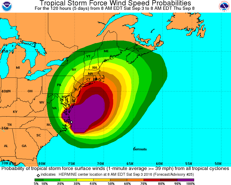
But the key concern is “tropical storm force winds” and a significant storm surge that may cause “moderate to major coastal flooding” at times of high tide beginning early Sunday afternoon, according to the National Weather Service.
Find out what's happening in Greenwichfor free with the latest updates from Patch.
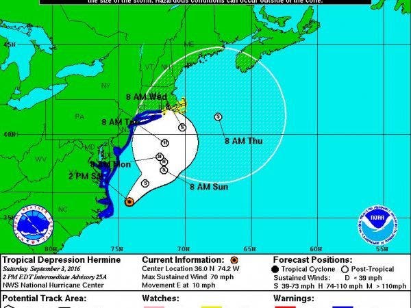
As of 2 p.m. Saturday, Hermine was about 330 miles southwest of New York City and moving east at 10 mph. Maximum sustained winds have now reached 70 mph, just 4 mph less than hurricane force.
The storm is expected to keep strengthening and it is projected to reach hurricane status by 8 p.m. Sunday when it will be centered a couple hundred miles south of Long Island, the National Hurricane Center says.
Find out what's happening in Greenwichfor free with the latest updates from Patch.
NBC Connecticut Meteorologist Ryan Hanrahan said, “Here's the latest information on Hermine. We are now expecting dry weather on Sunday with increasing wind and some showers Sunday night and Monday. Not a lot of rain - don't expect a wash out. The wind will be gusty - gusts up to 40 mph are expected and coastal flooding is possible on the Sound.”
Here is the latest on what we can expect on the Connecticut coast via the National Weather Service.
Wind gusts are expected to be 25-35 mph with gusts to 50 mph on Sunday and into Monday. Isolated gusts may approach 58 to 73 mph. The wind may lead to power outages, the weather service states.
The storm surge is expected to be 2-4 feet above ground beginning early Sunday afternoon. Damage to buildings, mainly near the coast is possible, the weather service states. There could be damage to marinas, docks, boardwalks, and piers too, the weather service says in a statement.
Most of the rain will be contained to Sunday night and Monday morning before it tapers off. Again, the story concerning this storm is the wind and storm surge.
We’ll continue to update this breaking news story.
Images via National Weather Service
Get more local news delivered straight to your inbox. Sign up for free Patch newsletters and alerts.