Community Corner
Weather: Wet, Windy, Not Quite Wicked
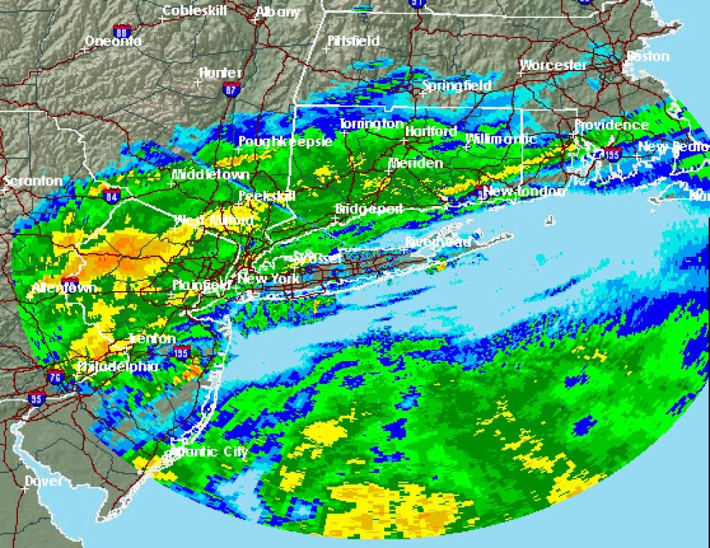
As much as 3 inches of rain is possible on Wednesday, according to the National Weather Service, which also cautions that there could be "significant" urban and small-stream flooding and higher tides than normal.

Update 7:35 a.m.:
Expect 1 to 2 inches of rain today and winds of 15 to 25 mph, but be ready for 2 to 3 inches sometime today and gusts of up to 30 mph this afternoon, the National Weather Service says.
"Significant urban and small-stream flooding is possible where bands of heavy rain develop," the weather service says in the latest "Hazardous Weather Outlook" forecast issued for the region at 6:51 a.m.
Find out what's happening in Greenwichfor free with the latest updates from Patch.
According to that forecast, tides should be 1.5 to 2.5 feet above normal, "possibly producing minor tidal flooding during the times of high tide today. Areas most impacted will be in western Long Island Sound." Greenwich is in western Long Island Sound.
"Water levels will locally touch or slightly exceed minor coastal flooding levels," the weather service stated in a "Coastal Flood Statement" issued at 4:57 a.m.
Find out what's happening in Greenwichfor free with the latest updates from Patch.
In its Greenwich-specific forecast, The rain could be heavy at times. High near 63. East wind between 9 and 16 mph. Chance of precipitation is 100%. New rainfall amounts between 1 and 2 inches possible.
Tonight: Showers, mainly before 1 am. Patchy fog. Low around 58. East wind between 7 and 13 mph. Chance of precipitation is 80%. New rainfall amounts between a half and three quarters of an inch possible.
Thursday: Partly sunny, with a high near 68. South wind between 9 and 16 mph.
Thursday Night: Partly cloudy, with a low around 48. Southwest wind between 8 and 10 mph.
Friday: Mostly sunny, with a high near 62. West wind between 8 and 14 mph.
Friday Night: Partly cloudy, with a low around 44.
Saturday: Mostly sunny, with a high near 59.
Saturday Night: Partly cloudy, with a low around 42.
Sunday: Mostly sunny, with a high near 59.
Sunday Night: Partly cloudy, with a low around 46.
Original article, Tuesday:
Rain, fast and hard, with winds gusting to as much as 33 mph, may be coming Wednesday, so if you take the umbrella, remember to hold it tight.
In a pair of forecasts, the National Weather Service says that there's a 100 percent chance of rain in Norwalk on Wednesday, with 1 to 2 inches "possible" according to the Norwalk-specific forecast, but "probable" according to the "Hazardous Weather Outlook" for the region.
A "heavier band of 2-3 inches [is] possible," according to the Hazardous Weather Outlook for southern Connecticut and the New York metropolitan region, which also states:
"Significant urban and small-stream flooding is possible where the heavy rain band sets up. East winds are forecast to increase to 15-25 mph, with gusths of 30 to 40 mph resulting in tidal departures from 1.5 to 2.5 feet above normal. This may cause some minor tidal flooding during the times of high tide Wednesday afternoon. This surge could be exacerbated in western Long Island Sound by wave action."
Thursday is expected to be "breezy" with winds of 14 to 20 mph possible. The skies should be partly sunny, with a high temperature of about 69 degrees. No rain is in Thursday's forecast.
Related Topics: hazardous weather outlook
Get more local news delivered straight to your inbox. Sign up for free Patch newsletters and alerts.