Neighbor News
WEATHER UPDATE: Several Inches of Snow and Ice Forecast for Connecticut
We'll let you know how much snow and ice to expect, when it will start and when it will finally end on Sunday.

How many weekends in a row has snow and or ice been in the forecast? The answer is too many, and this weekend is no exception. Actually, the answer is five.
Here is the latest update and what prominent Connecticut meteorologists and the National Weather Service are forecasting for Connecticut’s Saturday and Sunday’s snow and ice storm.
A Winter Weather Advisory has been issued for the entire state from Saturday afternoon until early Sunday.
Find out what's happening in Manchesterfor free with the latest updates from Patch.
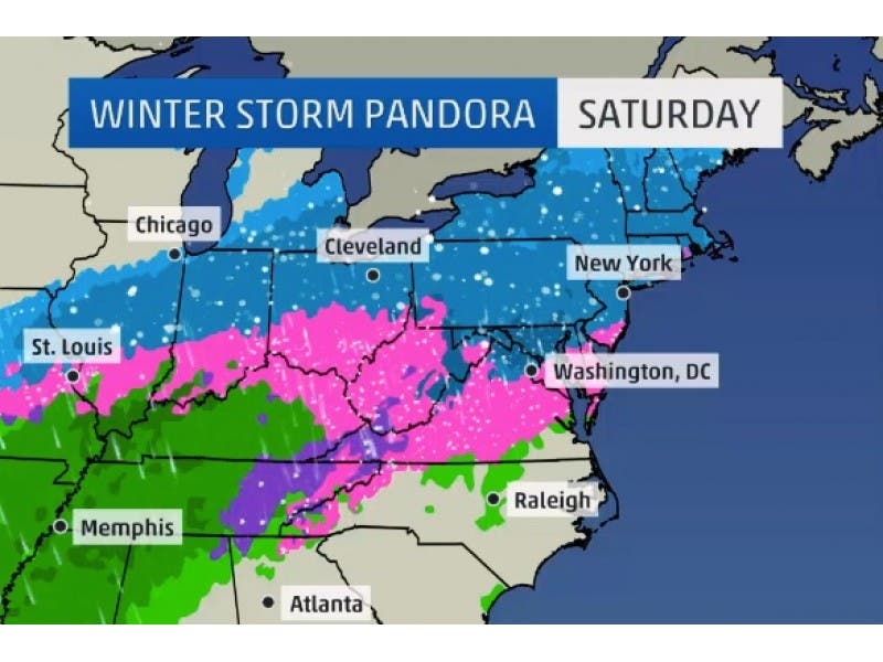
By-and-large everyone is on the same page for this latest storm, as they are predicting between 3-6 inches for most of the interior of Connecticut, and 2-4 inches on the immediate Connecticut Shoreline, and only an inch or two in far Southeastern Connecticut where the changeover to ice and plain rain will occur the quickest.
WFSB 3 TV Chief Meteorologist Bruce DePrest forecasts 3-6 inches of snow and the immediate coastline is looking at 1-3 inches.
Find out what's happening in Manchesterfor free with the latest updates from Patch.
On the plus side it will hit 40 degrees on Sunday but by Monday the temperature will be back in the teens! Enjoy the balmy 40 degrees for the few minutes it’s around on Sunday.
NBC Connecticut Chief Meteorologist Brad Field is also predicting 3-6 inches for most of the state and 1-3 inches for Southeastern Connecticut.
The National Weather Service is predicting 2-4 inches of snow and ice for the immediate coastline, and 3-6 inches of snow and ice for the majority of the state.
Hour-By-Hour Snow and Ice forecast:
WTNH News 8’s Meteorologist Kevin Arnone says snow will begin on the Shoreline between 2-4 p.m. and it will change to ice between 9-11 p.m., and end as plain rain between 12-2 p.m. on Sunday.
Inland, snow develops between 3-5 p.m. and it doesn’t change to ice until 2-4 a.m. and it ends as ice by 1-3 p.m. on Sunday.
Arnone predicts once the snow begins to fall, it will accumulate quickly.
NBC Connecticut Meteorologist Darren Sweeney writes on Facebook:
Saturday Morning Update:
We’re off to another stormy weekend (5th one in a row with some sort of weather alert)
The breakdown: Clouds by noon.
Snow arrives 2-4 PM (steadiest by dark).
Slippery travel, accumulating through evening.
A mix moves in mid evening (8-10PM) SE CT. That’s why accumulations will shut down first there, leading to 1-3” totals.
By midnight the mix line approaches the 84 corridor with an icy glaze of sleet and freezing rain. There could be a brief touch of rain (on the) 84 corridor, too, with temps getting above freezing. The problem is that the ground is so cold and right at the surface, it’s tough to get temps to respond to the air temp.
Treacherous travel overnight.
By morning a light drizzly icy mix ends 6-9 AM, then a mix of sun and clouds and get this.. MILD! Another arctic blast is coming, but it holds off until Sunday night/Monday. Highs approach the low 40s outside of the hilltowns Sunday. Teens/below 0 wind chills Monday.”
More stories on Patch:
Get more local news delivered straight to your inbox. Sign up for free Patch newsletters and alerts.