Weather
6K Power Outages In CT As A Foot Of Snow Fell In Most Places
The National Weather Service has issued a Special Weather Statement for parts of Connecticut this morning.


More than 10,000 Connecticut residents woke up to no power this morning as a major snowstorm dumped up to a foot of heavy, wet snow in parts of the state, which knocked down power lines and trees.
And while the snow has ended the travel concerns remain this morning. The National Weather Service released a Special Weather Statement for Southern Connecticut saying, "Precipitation has ended across the region. Temperatures across the area will remain around freezing through the morning commute, so any untreated surfaces will likely be slippery. Use extra caution if you plan to travel this morning as road conditions may be hazardous."
A major concern will be this evening when temperatures drop well below freezing and everything that melted this afternoon freezes, which will lead to black ice on roads. Temps remain very cold, and largely below the freezing mark this week, so this afternoon is your best chance to properly remove the snow or it will turn to ice.
Find out what's happening in Milfordfor free with the latest updates from Patch.
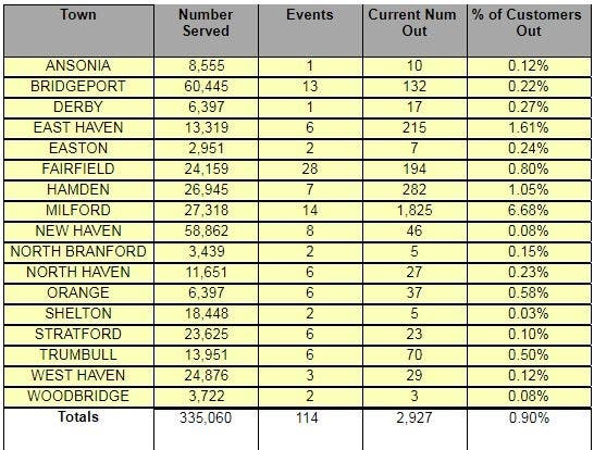
Eversource is reporting more than 3,743 outages as of 10:45 a.m. and United Illuminating has more than 2,900 outages. Check at the bottom of the story to see a town-by-town breakdown. (To sign up for free, local breaking news alerts from more than 100 Connecticut communities, click here.)
Here are all the road closures on Connecticut's major routes and highways as of 10:45 a.m.
Find out what's happening in Milfordfor free with the latest updates from Patch.
STONINGTON - Route 627 Mystic Road CLOSED at Meadow Wood Drive because of tree down with wires. Motorists are advised to use alternate route. Reported Monday, March 4 at 5:03 am.
WINDHAM - Rte 14 is closed @ Scotland Road for wires down. Reported Monday, March 4 at 9:47 am.
Arts, Crafts and Small Business Success Story In CT
Here is the work week weather forecast for Southern Connecticut:
Today
Cloudy, then gradually becoming mostly sunny, with a high near 39. Wind chill values between 25 and 30. North wind 10 to 13 mph becoming west in the afternoon.
Tonight
Mostly clear, with a low around 19. Wind chill values between 10 and 15. Northwest wind 8 to 11 mph.
Tuesday
Increasing clouds, with a high near 30. Wind chill values between 10 and 20. Southwest wind around 8 mph.
Tuesday Night
Mostly cloudy, then gradually becoming mostly clear, with a low around 19. Wind chill values between 10 and 15. West wind around 9 mph.
Wednesday
Mostly sunny, with a high near 29. Northwest wind 9 to 15 mph.
Wednesday Night
Partly cloudy, with a low around 13.
Thursday
Partly sunny, with a high near 29.
Thursday Night
Partly cloudy, with a low around 19.
Friday
Partly sunny, with a high near 35.
Friday Night
Mostly cloudy, with a low around 25.
Here is the work week weather forecast for Northern Connecticut:
Today
A chance of snow, mainly before 8am. Cloudy through mid morning, then gradual clearing, with a high near 38. Northwest wind 7 to 9 mph, with gusts as high as 22 mph. Chance of precipitation is 30%. Total daytime snow accumulation of less than a half inch possible.
Tonight
Clear, with a low around 16. Northwest wind 3 to 7 mph.
Tuesday
Sunny, with a high near 30. Calm wind becoming southwest 5 to 7 mph in the morning.
Tuesday Night
Partly cloudy, with a low around 16. Southwest wind around 6 mph becoming northwest after midnight.
Wednesday
Mostly sunny, with a high near 25. Northwest wind 6 to 10 mph, with gusts as high as 23 mph.
Wednesday Night
Partly cloudy, with a low around 8. Northwest wind 3 to 7 mph.
Thursday
Mostly sunny, with a high near 28. West wind 5 to 7 mph.
Thursday Night
Mostly clear, with a low around 13. Northwest wind 5 to 7 mph becoming calm in the evening.
Friday
Mostly sunny, with a high near 34. Southwest wind 3 to 6 mph.
Friday Night
Mostly cloudy, with a low around 22. Light and variable wind.
Eversource outages
| Town Name | Customers Served | Estimated Customers Out | % of Total |
|---|---|---|---|
| BLOOMFIELD | 10601 | 80 | 0.75 |
| BRANFORD | 16596 | 18 | 0.11 |
| BROOKLYN | 3658 | 1 | 0.03 |
| CHESTER | 2084 | 4 | 0.19 |
| CLINTON | 7112 | 28 | 0.39 |
| COVENTRY | 5641 | 1 | 0.02 |
| DANBURY | 37236 | 1 | 0.00 |
| DARIEN | 8084 | 196 | 2.42 |
| EAST GRANBY | 2648 | 141 | 5.32 |
| EAST HADDAM | 4897 | 13 | 0.27 |
| EAST HARTFORD | 23223 | 92 | 0.40 |
| EAST LYME | 10079 | 9 | 0.09 |
| EASTFORD | 913 | 102 | 11.17 |
| ENFIELD | 19404 | 8 | 0.04 |
| ESSEX | 4013 | 1 | 0.02 |
| FARMINGTON | 12765 | 1 | 0.01 |
| FRANKLIN | 1020 | 1 | 0.10 |
| GLASTONBURY | 16652 | 12 | 0.07 |
| GRANBY | 4843 | 1 | 0.02 |
| GREENWICH | 28150 | 291 | 1.03 |
| GRISWOLD | 3407 | 3 | 0.09 |
| GUILFORD | 11036 | 17 | 0.15 |
| HADDAM | 3962 | 2 | 0.05 |
| HARTFORD | 59069 | 28 | 0.05 |
| KENT | 2146 | 1 | 0.05 |
| KILLINGLY | 8879 | 40 | 0.45 |
| KILLINGWORTH | 2878 | 99 | 3.44 |
| LEDYARD | 6781 | 7 | 0.10 |
| LISBON | 1862 | 1 | 0.05 |
| LYME | 1338 | 36 | 2.69 |
| MADISON | 9192 | 41 | 0.45 |
| MANSFIELD | 7443 | 2 | 0.03 |
| MERIDEN | 28188 | 2 | 0.01 |
| MIDDLETOWN | 23043 | 25 | 0.11 |
| MONTVILLE | 8055 | 1 | 0.01 |
| NEW BRITAIN | 34681 | 4 | 0.01 |
| NEW CANAAN | 8460 | 60 | 0.71 |
| NEW MILFORD | 13952 | 4 | 0.03 |
| NEWINGTON | 14824 | 35 | 0.24 |
| NEWTOWN | 11320 | 4 | 0.04 |
| NORTH STONINGTON | 2615 | 249 | 9.52 |
| NORWALK | 31357 | 748 | 2.39 |
| OLD LYME | 5495 | 3 | 0.05 |
| OLD SAYBROOK | 7129 | 16 | 0.22 |
| PLAINFIELD | 7217 | 1 | 0.01 |
| PRESTON | 2217 | 5 | 0.23 |
| PUTNAM | 5218 | 1 | 0.02 |
| REDDING | 3830 | 1 | 0.03 |
| SEYMOUR | 7652 | 1 | 0.01 |
| SIMSBURY | 10989 | 16 | 0.15 |
| SOUTH WINDSOR | 12148 | 12 | 0.10 |
| SOUTHBURY | 9992 | 2 | 0.02 |
| SOUTHINGTON | 20044 | 10 | 0.05 |
| STAMFORD | 60259 | 248 | 0.41 |
| STONINGTON | 10831 | 102 | 0.94 |
| VERNON | 16300 | 1 | 0.01 |
| VOLUNTOWN | 1321 | 1 | 0.08 |
| WATERBURY | 51705 | 3 | 0.01 |
| WATERFORD | 9789 | 8 | 0.08 |
| WEST HARTFORD | 28711 | 22 | 0.08 |
| WESTBROOK | 4658 | 14 | 0.30 |
| WESTON | 3868 | 34 | 0.88 |
| WESTPORT | 12570 | 1094 | 8.70 |
| WETHERSFIELD | 12462 | 36 | 0.29 |
| WILTON | 7545 | 26 | 0.34 |
| WINDHAM | 10301 | 3 | 0.03 |
| WINDSOR | 13404 | 94 | 0.70 |
| WINDSOR LOCKS | 6408 | 1 | 0.02 |
| WOODBURY | 5191 | 1 | 0.02 |
| WOODSTOCK | 4177 | 101 | 2.42 |
UI outages
Get more local news delivered straight to your inbox. Sign up for free Patch newsletters and alerts.