Community Corner
WEATHER UPDATE: Heavy Rain, Hazardous Weather Outlook Issued for Monroe
The rain, which will be possibly heavy at times, will begin Saturday morning and could result in some flooding of poor drainage areas.

And we thought we’d escape the weekend without any weather advisories! Well not so fast!
The National Weather Service has issued a “Hazardous Weather Outlook” for the area for late tonight and Saturday for heavy rains, the chance of some ice, and the possibility of some flooding.
According to the National Weather Service’s “Hazardous Weather Outlook,” ‘periods of rain late tonight, any ice accumulation would be less than a tenth of an inch.
Find out what's happening in Monroefor free with the latest updates from Patch.
There is a low chance of ice jam flooding of rivers and streams due to snow melt and rainfall Saturday and Saturday night,” the National Weather Service predicts.
It’s possible the precipitation, which begins to fall early Saturday may begin as a little ice and sleet, but will quickly change to a cold soaking rain that will last until early Sunday, and may end as some snow showers.
Find out what's happening in Monroefor free with the latest updates from Patch.
Between a half-inch and three-quarters of an inch of rain is predicted.
NBC Connecticut Meteorologist Darren Sweeney writes on Facebook that for the weekend expect:
“As mentioned in my last post, the amount of wintry precip we get over the weekend depends on amount of cold air, evolution of storm track etc.
It looks like mostly a cold rain with some sleet freezing rain early on in the am. Don’t be surprised to see some snow showers on Sunday. Looks like a blustery and chilly week ahead.
We go from 50-ish and feeling fab to feeling wind chills. You have to just love March in New England,” Sweeney wrote on social media.
Here is the National Weather Service’s hyperlocal weekend forecast for Monroe:
- This Afternoon: Mostly sunny, with a high near 39. South wind around 6 mph.
- Tonight: Freezing rain likely, mainly after 5am. Increasing clouds, with a low around 30. South wind 3 to 5 mph. Chance of precipitation is 60%. Little or no ice accumulation expected.
- Saturday: Rain or freezing rain likely before 7am, then rain. High near 44. Light and variable wind becoming southeast around 6 mph. Chance of precipitation is 100%. Little or no ice accumulation expected.
- Saturday Night: A chance of rain before midnight, then a chance of showers after midnight. Mostly cloudy, with a low around 34. Northwest wind around 6 mph. Chance of precipitation is 40%.
- Sunday: Mostly cloudy, with a high near 43. Northwest wind 7 to 11 mph.
- Sunday Night: Mostly cloudy, with a low around 27.
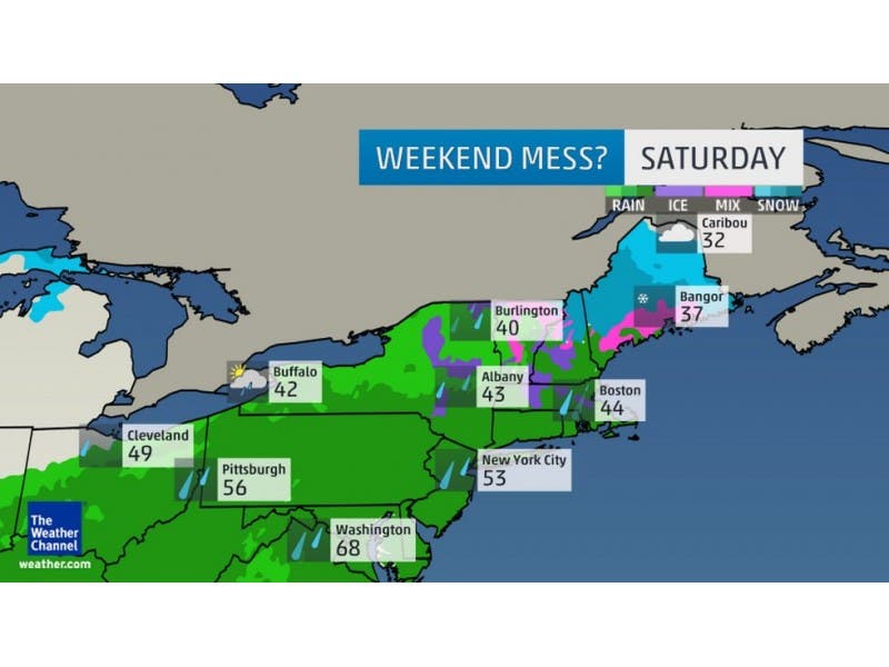
Image screenshot from the Weather Channel
Want more weather alerts? Sign up below!
Get more local news delivered straight to your inbox. Sign up for free Patch newsletters and alerts.