Health & Fitness
Take a Trip on the Air Line Trail: Part 2 of 2
The Air Line Trail Northern section spans 27 miles through Windham, Chaplin, Hampton, Pomfret, Putnam, and Thompson.


This is part 2 of a series on the Air Line Trail State Park. Last week focused on the southern segment (East Hampton, Colchester, Hebron, Columbia, and Lebanon) while this week focuses on the northern section (Windham, Chaplin, Hampton, Pomfret, Putnam, and Thompson).
Compared to its calmer northern sister, the 27-mile Air Line Trail North is more adventurous.
The southern trail goes through Connecticut’s Quiet Corner in the northeastern section of the state.
Find out what's happening in Montvillefor free with the latest updates from Patch.
The DEEP says that the northern section is, “mainly undeveloped and favored by heartier hikers, those using mountain bikes and riding horses. Some sections are in poor repair with surface conditions featuring the original rail ballast and are considered only barely passable even on foot.”
Cross country skiing and leashed pets are also allowed on the trail.
Find out what's happening in Montvillefor free with the latest updates from Patch.
The most undeveloped parts of the trail are in eastern Pomfret and Thompson.
There are plans to improve Pomfret’s trail for a link to the smooth 1.32-mile Putnam River Trail, which is my favorite portion of the northern section.
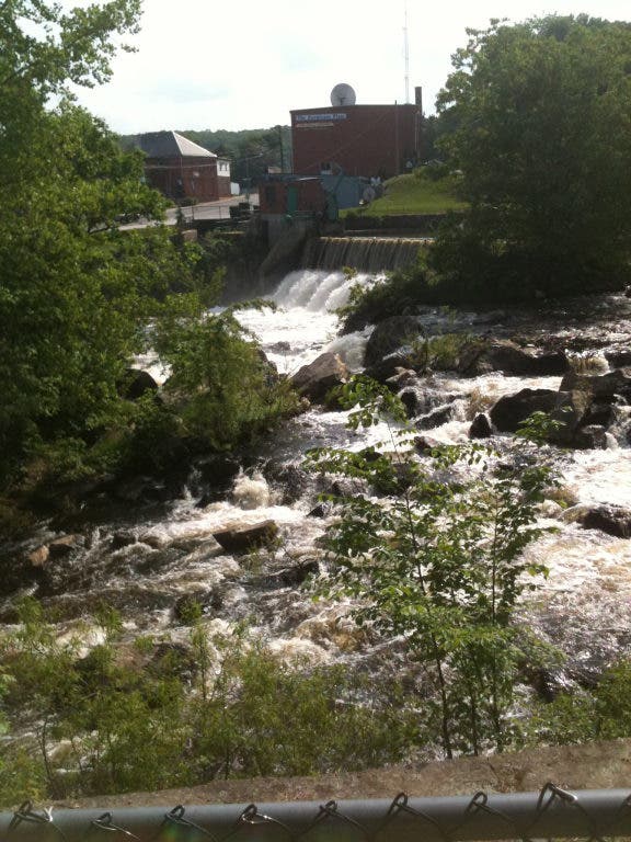
Putnam River Trail takes visitors over a former railroad bridge, past the Quinebaug River, and to the beautiful Cargill Falls.
Informational signs on the trail tell visitors about Putnam’s founding and the Flood of 1955, which washed out critical bridges in Putnam leading to the crippling of the Air Line Railroad.
The trail includes several parking lots, a band stand for live entertainment, and easy access to Downtown Putnam and Riverfront Commons.
Putnam River Trail also has a connection to the historic River Mills Trail in Putnam.
Air Line Trail North has other improved sections, like the Kensington Spur Trail in Windham, a segment from the intersection of Routes 6 and 66 in North Windham to Route 203, a fragment inside the 2,000-acre James L. Goodwin State Forest in Hampton, and a portion near the Mashamoquet Brook State Park in Pomfret.
Goodwin Forest features an additional 14 miles of hiking, a conservation education center, as well as diverse recreational opportunities including snow shoeing, kayaking, camping, fishing, horseback riding, bird watching, biking, and letterboxing.
For the energetic hiker, it is an eight-mile hike from Goodwin to the Northeast Connecticut Audubon Center in Pomfret.
Those looking for a challenge can trek on a windy portion of the trail by parking at the large pull-off parking area at the intersection of Chenwick and Lynch Roads in Chaplin.
Anticipated improvements to Thompson’s treacherous 6.6-mile section would connect it to the Southern New England Trunkline Trail in Douglas, Mass.
Another proposal would create signage in Thompson to mark the spot where three states, Connecticut, Rhode Island, and Massachusetts, intersect.
Travelers should use caution when venturing out to the undeveloped parts of the southern trail.
The DEEP, National Recreational Trail Program, various towns, environmental groups, and volunteers are working hard to improve the Air Line Trail with the hopes of creating a smooth route from East Hampton to Thompson that everyone can enjoy.