Health & Fitness
Take a Trip to the Air Line Trail: Part 1 of 2
Part 1 of a 2-part series on the Air Line Trail State Park which goes through 11 Eastern Connecticut towns.


This is part 1 of a series on the Air Line Trail State Park. The southern segment of the trail (East Hampton, Colchester, Hebron, Columbia, and Lebanon) will be explored in this part with the northern section (Windham, Chaplin, Hampton, Pomfret, Putnam, and Thompson) explored next week in part 2.
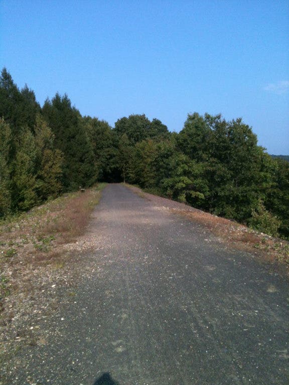
If you’re looking for a unique place to walk, jog, bike, cross country ski, or take your dog or horse, consider heading on up to the quaint and peaceful 23-mile Air Line Trail South.
According to the DEEP, this section’s “surface conditions vary from compacted earth and crushed rock to gravel and stone dust.”
Find out what's happening in Montvillefor free with the latest updates from Patch.
The park has a rich history as it was the former Air Line Railroad connecting Boston with New York City, as if a line was drawn through the air via the City of New Haven.
I recently took a Thursday afternoon walk at the Lyman Viaduct, which is one of the most interesting parts of the trail. The viaduct provides a breathtaking view of the surrounding forest about 137 feet high above Dickinson’s Creek.
Find out what's happening in Montvillefor free with the latest updates from Patch.
The Lyman Viaduct was home to a 1,080-foot-long railroad bridge, built in 1873. To accommodate freight trains, the bridge was filled up to the top with gravel in 1913. It is only one and a half miles from its twin sister, the Rapallo Viaduct, formerly home to a 1,380-foot-long railroad bridge. It is about 60 feet above Flat Brook.
During my journey, I encountered folks of various ages; joggers, walkers with dogs, and bicyclists. I walked about a mile from the Bull Hill Road parking lot in Colchester to just past the viaduct. I enjoyed the sunny day by taking a few minutes and relaxing at one of the many benches.
It is quite helpful that this section of the trail has GPS reception. I was able to see how far I walked and the distance to parking areas and road crossings along the trail.
For those without GPS, mile marker signs have been installed.
The trail goes westward through East Hampton past Cranberry Bog, Lake Pocotopaug, and, finally, its newest section, Bell Town Village Center.
Going eastward along the trail from Bull Hill Road, folks will enjoy scenic views of Hebron and Lebanon including Salmon River State Forest, Grayville Falls Park, Raymond Brook Marsh, Turnerville Station, and Lake Williams.
There is also a connection in Hebron to the three-mile Colchester Spur going to Colchester Station and Colchester’s Town Center.
Travelers will see that underneath the trail at stream crossings are lovely arched bridges. Many were built with brownstone from Connecticut quarries.
On the trail itself is the River Road Bridge, a 22-foot-long brownstone 1887 arch bridge, which once carried trains 18 feet above the unpaved portion of River Road.
The best place to park on the eastern end is at the former Route 85 Lumber in Hebron.
The park is open 8 a.m. to sunset daily. There is no fee to visit the park and all motorized vehicles are prohibited.