Home & Garden
CT Forecast: Snow Showers for MLK Weekend, Real Snowstorm Emerging Next Weekend
The entire state may see some snowflakes Sunday, but it's possible you'll need a shovel next weekend.

There is a good chance you’ll see some white stuff falling from the sky this afternoon and evening. Snow showers are also possible on Martin Luther King Jr. Day, but don’t panic we’re not talking anything significant.
The chance for the state’s first real snowstorm this winter is possible but not until next weekend, says NBC Meteorologist Darren Sweeney and Ryan Hanrahan. More on that in a bit.
The Here and Now
Snow showers are possible beginning any time after 1 p.m. throughout the state of Connecticut, and it could actually add up to an inch of snow in Hartford and Tolland counties where a “Hazardous Weather Outlook” has been issued for today and Monday.
The weather service writes that up to two inches of snow is possible in certain areas and a slick morning commute on Monday is possible for those who have to go into work.
For the rest of the state, we may see some pretty snowflakes but you can leave the shovel inside. The snow showers, if they fall should end around midnight and could begin after 9 a.m. and 10 a.m. on Martin Luther King Jr. Day, the weather service writes.
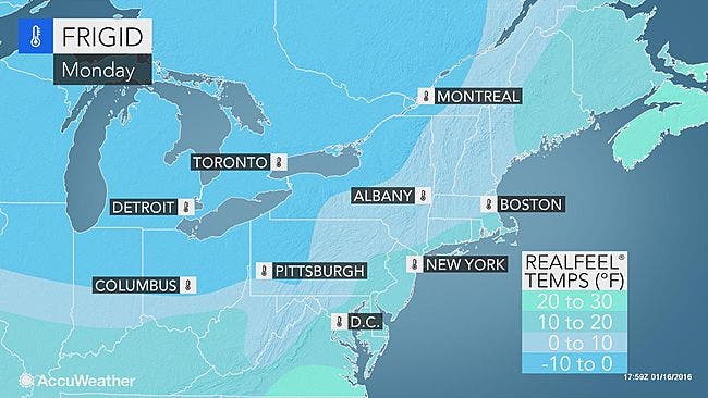
The Wind and Bitter Cold Returns
In Hartford and Tolland counties it’s going to be really windy with gusts near 50 mph. During Monday for the rest of the state the wind gusts will make it feel like as cold as 10 degrees and high temps will be in the 20s for the state.
The temps on Sunday night will fall back into the teens and low 20s.
The Work Week Forecast
Tuesday through Friday appears dry and sunny but cold, with high temps in the upper 20s to low 30s for Connecticut and into the teens and 20s at night. So basically seasonal weather for this time of year.
Real Snow Threat Emerging
NBC Meteorologist Darren Sweeney wrote on Facebook Sunday morning that “Snow fans, models are pointing to a storm threat at the end of the week. This animation is the ECMWF or “Euro” (European model) and it has support from its ensemble members and even the American GFS model brings a storm close to the coast.
There is also cold air in place.. LOTS will change between now and Friday/Saturday (the storm isn’t even onshore yet) but a heads up to stay with the #FirstAlertCT forecast team as we constantly get new data into the forecast center. “
NBC Connecticut Meteorologist Ryan Hanrahan wrote on his blog that,
“Is it possible? An actual snow threat during this dud of a winter? The overnight computer model runs have all trended much more impressive with a potential snow threat next Saturday across the state.”
Hanrahan now puts the chances of a real snowstorm next weekend at higher than 50 percent based on the newest computer models.
For a more detailed analysis of next weekend’s possible snow chance read Hanrahan’s blog here.
Photo credit: Accuweather.com
Get more local news delivered straight to your inbox. Sign up for free Patch newsletters and alerts.