Home & Garden
NEW CANAAN WEATHER ALERT: Heavy Rain, Possible Flooding Forecast for Connecticut
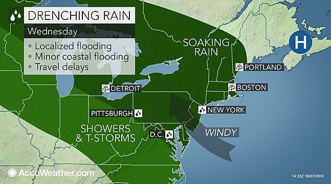
We'll let you know what to expect for Wednesday's morning commute and when the worst of the heavy rain is expected.

It has rained so infrequently over the past several months that it’s major news when a heavy rainstorm is headed to Connecticut.
And that is exactly what we have in the forecast beginning just after Wednesday’s morning commute to work and school.
Most of Connecticut is in the midst of “moderate drought” conditions and Wednesday’s soaking rains will definitely help in that regard.
Find out what's happening in New Canaanfor free with the latest updates from Patch.
The entire state of Connecticut is looking at up to 2 inches of rain, some strong wind gusts, isolated thunderstorms, especially in the evening, and minor flooding concerns, according to the National Weather Service’s latest forecast.
The good news is it will likely be dry when you head out the door to work or to take the kids to school or to the bus stop Wednesday morning.
Find out what's happening in New Canaanfor free with the latest updates from Patch.
Timing
In southwestern Connecticut, light rain could begin after 8 a.m. but the showers should hold off for the majority of the state until around 10 a.m.
In northern Connecticut, rain isn’t expected until around 12 p.m., the National Weather Service writes.
Up to a half inch to three quarters of rain is forecast for the entire state during the day and an additional 1-2 inches of heavy rain is expected at night along with some fog, wind gusts, and isolated thunderstorms.
The rain is expected to end by 8 a.m. Thursday for southern Connecticut and by 9 a.m. for Hartford and Tolland counties. Conditions will improve throughout the day on Thursday and temps could exceed 70 degrees.
Posted Weather Alerts
The National Weather Service has issued a “Coastal Flood Advisory” for southern Fairfield and southern New Haven counties between 11 a.m. and 2 p.m. Wednesday for the possibility of minor flooding at the time of high tide.
Roads near the immediate coastline could incur flooding.
For Hartford and Tolland counties, there is a “Hazardous Weather Outlook” posted for the possibility that strong southerly winds may down small tree limbs and branches causing power outages. Also, the heavy rain could lead to some drainage flooding, the weather service predicts.
Staying Warm
NBC Connecticut Meteorologist Darren Sweeney on his blog wrote as November approaches people are anticipating winter’s return but not so fast.
In fact, the start of November looks warm, Sweeney wrote, and we could find ourselves “well above average.”
Next week, Connecticut could hit 70 degrees, Sweeney predicts adding, “Despite turning the clocks back and that earlier sunset, lets not count autumn out just yet.”
Photo Credit: Accuweather.com
Get more local news delivered straight to your inbox. Sign up for free Patch newsletters and alerts.