Weather
New Details on Hurricane Hermine's Potential Impact on Connecticut This Labor Day Weekend
Hermine has been upgraded to a hurricane Thursday, and there is new information concerning what impact the storm may have on Connecticut.

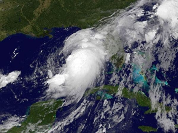
Hurricane Hermine has officially formed off Florida's Gulf Coast. The storm is the fourth hurricane of the 2016 Atlantic Hurricane Season and the first one expected to strike Florida in nearly 11 years.
No, Hurricane Hermine is not going to hit Connecticut, but forecasters are monitoring what impact the massive storm may have on the state this Labor Day weekend. In an update, the National Weather Service is now saying Thursday that Connecticut, especially southern Connecticut, could be impacted beginning Saturday and lasting into Tuesday by Hermine.
The National Hurricane Center reported that Hurricane Hermine was located about 175 miles west of Tampa at 3 p.m. Thursday. The storm was packing maximum sustained winds of 75 mph and was moving north-northeast at 14 mph. It is expected to make landfall along Florida's northern Gulf Coast or in the Big Bend area sometime late Thursday or early Friday. It will be the first hurricane in Florida since 2005's deadly Hurricane Wilma made landfall in the Sunshine State.
Find out what's happening in New Canaanfor free with the latest updates from Patch.
As of Thursday afternoon, tropical storm force winds were extending outward from the storm up to 185 miles to the northeast and southeast of the center, forecasters say.
On its present track, Hurricane Hermine is expected to cut across northern Florida Friday before heading toward Georgia and South Carolina. The storm is anticipated to then move through parts of North Carolina early Saturday morning before continuing in a northeasterly direction that could bring it in contact with Virginia and Maryland late in the weekend.
Find out what's happening in New Canaanfor free with the latest updates from Patch.
What impact will Hermine have on Connecticut? Here's the current thinking.
The National Weather Service now says Hermine may start to impact the state as early as Saturday and have an effect into Tuesday, especially in southern Connecticut. Northern Connecticut may just see showers and periods of rain on Sunday and Monday.
The impacts, especially for southern Connecticut, include coastal flooding, as well as possible heavy rain and strong winds, depending on the storm's track, the weather service states. There is a "moderate risk" for rip currents as well as moderate risk for beach erosion that may linger into early next week, the weather service states.
In southern Connecticut, rain could start falling after midnight Saturday and continue through Monday night, the weather service states. In northern Connecticut, which is of course father from the storm, the rain chance starts around midday Sunday and continues through Monday night but it's only about a 50 percent chance currently, according to the NWS.
NBC Connecticut Meteorologist Ryan Hanrahan said in an afternoon update via his Facebook page that "Hermine is a tough one to figure out. We have high confidence that the storm will stall off the Mid Atlantic coast this weekend.
The issue is how far north? A stall off Atlantic City will result in significant impacts here (gusty winds, heavy rain, coastal flooding, scattered power outages) while a stall off Maryland will result in minimal impact (a few showers and a breeze). Right now we do not know which solution will verify but we are watching it very closely and will keep you impacted every step of the way. If you have any questions, comments, or criticism please let me know!"
WTNH News 8 Meteorologist Gil Simmons wrote on his Facebook page, "I think we will have a much better handle on how far north the storm gets tomorrow. At this point, shoreline wind gusts and coastal flooding are the two main concerns Sunday-Monday.
See also: These 25 Connecticut Business Had Their Liquor Licenses Suspend
Image courtesy of the National Hurricane Center
Written by Sherri Lonon and Brian McCready, Patch Staff
Get more local news delivered straight to your inbox. Sign up for free Patch newsletters and alerts.