Community Corner
WEATHER UPDATE: Flood Advisory Issued for Oxford
The weather improves later in the week and then there are storms possible for this coming weekend.

Update 2:15 p.m. The National Weather Service has issued a Flood Advisory for the area until 4:45 p.m. as local radar states heavy rain is likely and rain rates could reach up to 1 to 1.5 inches per hour at times and lead to flooding concerns.
Also a special weather statement was issued for Oxford:
A STRONG THUNDERSTORM WILL AFFECT CENTRAL FAIRFIELD AND WEST
CENTRAL NEW HAVEN COUNTIES...
Find out what's happening in Oxfordfor free with the latest updates from Patch.
AT 219 PM EDT...A STRONG THUNDERSTORM WAS OVER SOUTHBURY...MOVING
SOUTH AT 15 MPH.
WINDS IN EXCESS OF 40 MPH AND PEA SIZE HAIL ARE POSSIBLE WITH THIS
STORM.
Find out what's happening in Oxfordfor free with the latest updates from Patch.
TORRENTIAL RAINFALL IS ALSO OCCURRING WITH THIS STORM...AND MAY
CAUSE LOCALIZED FLOODING. DO NOT DRIVE YOUR VEHICLE THROUGH FLOODED
ROADWAYS.
FREQUENT CLOUD TO GROUND LIGHTNING IS OCCURRING WITH THIS STORM.
LIGHTNING CAN STRIKE 15 MILES AWAY FROM A THUNDERSTORM. SEEK A SAFE
SHELTER INSIDE A BUILDING OR VEHICLE.
THIS STORM MAY INTENSIFY
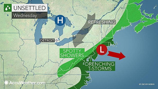
Original post: Like almost everyday this week there is a chance of showers and thunderstorms for all of Connecticut on Wednesday.
Showers and thunderstorms could begin anytime after 11 a.m. but the National Weather Service predicts if we do get showers and storms it’s mostly likely in the afternoon and early evening hours.
The weather service writes that the chance of showers and storms is 60 percent, and if it does rain expect it to be heavy for that period of time.
The rain is expected to end by 8 p.m. for all of Connecticut. A Hazardous Weather Outlook has been issued for Hartford and Tolland county because in addition to the chance for showers and storms it’s also possible there could be some flooding concerns too.
After we get through today, we’ll enjoy better weather for Thursday and Friday with sunny skies and temps around 80 degrees.
Beginning on Saturday and through Tuesday there is a chance for storms each day, but sun is also forecast as well, so who knows.
WTNH News 8 Meteorologist Gil Simmons writes on Facebook, “A quiet start followed by a stormy finish today. Tropical humidity for one more day today! Good morning!”
Click here for Oxford’s Detailed and Extended Forecast
Photo credit: Accuweather.com
Get more local news delivered straight to your inbox. Sign up for free Patch newsletters and alerts.