Home & Garden
Rain and Snowflakes in Shelton's Workweek Forecast
Like last week, we're looking at another mid-week storm for the area and a cool down in temps by the end of the week.

By Brian McCready
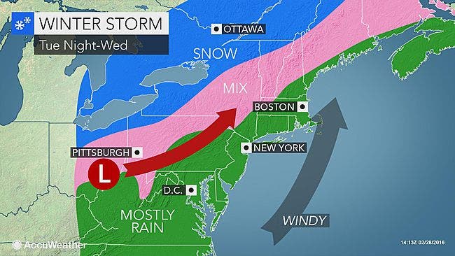
This week’s forecast resembles last week’s in some ways. Once again, we’re facing a mid-week storm but the good news is this one doesn’t appear anywhere near as strong as the one that left 90,000 Connecticut residents without power last Thursday.
- To sign up for closings, weather and breaking news alerts for Shelton, click here.
- Like Shelton Patch on Facebook by clicking here.
- Click here for your local, extended forecast for Shelton.
And while temps will be warmer on average, we still have a couple of chances to see some snowflakes during the workweek forecast.
Here are the latest details from the National Weather Service:
- Monday: Showers early this afternoon are possible with temps in the mid-50s, but also expect partly sunny skies at times too.
- Monday night: Clear skies with temps right around the freezing mark.
- Tuesday: Mostly sunny skies with temps in the low 40s.
- Tuesday night: Rain is forecast after midnight, it may start as some snow too and transition to a brief period of ice, but no wintry precipitation accumulation is expected. Temps will rise throughout the night and it will be plain rain after midnight. A half-inch of rain is possible.
- Wednesday: Rain is expected to fall into the middle of the afternoon, and winds could be gusty, reaching up to 30 mph in places. Another half-inch of rain is possible.
- Temps will drop sharply during the day and then Wednesday evening there is a chance for some snow but as of right now no snow accumulation is expected.
- Thursday: Sunshine with temps in the mid to upper 30s.
- Thursday night: Winter returns as temps may barely reach 20 degrees
- Friday: Chance of snow and temps near the freezing mark in southern Connecticut.
- The weekend: Saturday, chilly with sunshine and temps in the upper 30s and Sunday, temps inch up higher into the low 40s with sunny skies once again.
Photo credit: AccuWeather.com
Get more local news delivered straight to your inbox. Sign up for free Patch newsletters and alerts.