Home & Garden
Shelton Hazardous Weather Alert: C-C-C-Cold and Snowy!
Snow showers are expected Thursday in Shelton with below zero, bone chilling temperatures.

By Brian McCready
The National Weather Service has already issued a “Hazardous Weather Outlook” for possibly record cold this weekend and a chance for more snow coming up.
Parts of Connecticut have been dealing with heavy snow showers this morning, which has put a coating to an inch of new snow on the ground.
More snow showers are possible until later this afternoon but it will be hit and miss as to who actually ends up seeing snowflakes and who doesn’t. Currently, a half inch is possible for Fairfield county, according to the National Weather Service.
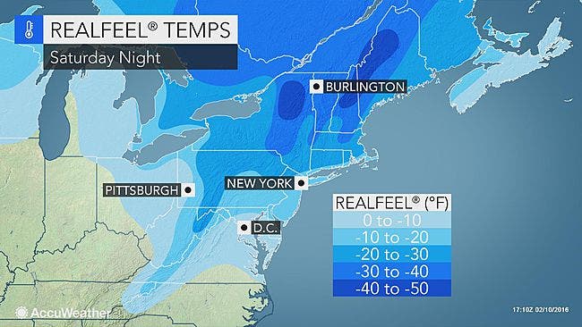
After the light snow chance fades today, everyone’s attention turns to the weekend, and a “Hazardous Weather Outlook” has already been issued for the entire state for the coldest air of the winter season. The entire state will likely find itself below zero Saturday night.
Here is the latest from the National Weather Service for Fairfield County:
- Temps will fall to zero to 5 below combined with winds of 15 to 25 mph that could produce dangerous wind chills of around 25 below late Saturday night into early Sunday morning.
- Temps on Friday night will range from 12-16 degrees for a low, on Saturday temps will be near 15-18 degrees and at night everyone is forecast to be below zero with temps ranging from -1 to -6. Sunday temps will again be in the upper teens and at night around 5 above zero.
- Then “significant” wintry precipitation is forecast for Monday night into Tuesday morning, and then it turns to plain rain and flooding is likely later on Tuesday.
- On Friday night temps will be 14 degrees, on Saturday temps will be near 15 degrees and around -3 Saturday night. On Sunday, temps will be near 12-14 degrees and the low near 5 degrees.
- And yes, snow is likely Monday night, turning to heavy rain Tuesday, which could cause flooding later on Tuesday.
- On Friday night, temps will be near 13 degrees, Saturday temps will be around 15 degrees and on Saturday night around -7 degrees. Sunday’s highs only are around 10 degrees and once again it’s below zero on Sunday night.
- Snow and rain are possible early Tuesday into Tuesday afternoon and evening.
Photo credit: AccuWeather.com
Get more local news delivered straight to your inbox. Sign up for free Patch newsletters and alerts.