Weather
Hazardous Weather Outlook Issued for Southington
We'll let you know when more snow is possible this week and just how cold it will feel by the end of the week.

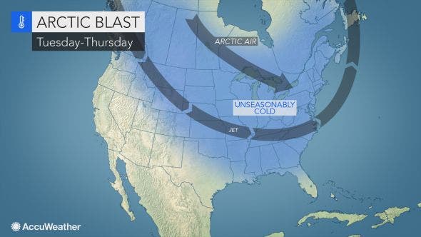
There are more snow chances in the upcoming forecast and brutally cold temps and wind chills are also in the forecast beginning on Thursday in Connecticut.
The first chance for some very light snow is actually late Tuesday night and early Wednesday, and it looks like some snow that may accumulate in at least parts of the state is possible on Saturday. The big story is daytime highs will only reach into the low- to mid-20s by Thursday and temps at night will be in the single digits to low teens and wind chill factors will be well below zero.
The National Weather Service has already issued a Hazardous Weather Outlook for Hartford and Tolland counties for “dangerously cold wind chills of 10- to 25-below zero” on Thursday night into Friday morning. Winds could gust here up to 45 mph. And accumulating snow is in the forecast here for Saturday and a Winter Weather Advisory may need to be issued here.
Find out what's happening in Southingtonfor free with the latest updates from Patch.
As for Southern Connecticut, it’s not exactly going to feel like South Beach, but the temps will be a bit warmer than northern Connecticut and light snow and a mix of precipitation is also forecast here for Saturday too.
WTNH News 8 Meteorologist Gil Simmons said, “Plan on a chilly day today actual temperatures will get into the 40s but it will feel like 30s with the wind. A little touch of light snow possible overnight tonight it could be a little bit slippery early tomorrow. And severe cold coming in Thursday and Friday followed by a little bit of snow on Saturday morning!”
Find out what's happening in Southingtonfor free with the latest updates from Patch.
Updated forecast for Hartford and Tolland counties:
Tuesday: Cloudy, high near 39. Chance of snow showers from 8 p.m. until 3 a.m.
Wednesday: Sunny, high near 35. Chance of some light snow after midnight.
Thursday: A chance of snow. Partly sunny high near 24. Temps drop to near zero at night. Dangerous wind chills.
Friday: Sunny, high only in the teens. Snow after 3 a.m. overnight.
Saturday: Snow likely before 2 p.m. and then a mix before it ends in the late afternoon.
Image via Accuweather.com
Get more local news delivered straight to your inbox. Sign up for free Patch newsletters and alerts.