Community Corner
Update: Tropical Storm Gonzalo Forms
Forecasters don't think it will pose many problems for the Tampa Bay area.


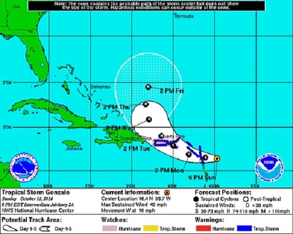
Update Oct. 12, 8:20 p.m.: The National Hurricane Center has officially upgraded the disturbance near the Leeward Islands to tropical storm status. The storm is expected to reach hurricane strength over the next few days, but isn’t expected to impact Florida.
Earlier:
Hurricane season isn’t quite over and Mother Nature seems to be proving that point by kicking up some action in the tropics with two storm currently under watch by forecasters.
Find out what's happening in Clearwaterfor free with the latest updates from Patch.
Those storms, however, aren’t likely to have much of an impact, if any, on the Tampa Bay area, forecasters at the National Weather Service say.
The first disturbance is Tropical Storm Fay. She’s currently spinning in the Atlantic, but is far away from the mainland and is continuing to move east.
Find out what's happening in Clearwaterfor free with the latest updates from Patch.
The second disturbance is forming near the Leeward Islands. That storm has a 90 percent chance of developing into a tropical cyclone within the next 48 hours. Forecasters say it’s moving westward, but it is too early to tell exactly where it will go over the next few days.
A plane is expected to fly out to investigate the storm sometime Sunday, said meteorologist Tyler Fleming. At this point, forecasters don’t think the storm, which would be named Gonzalo if it forms, will have a big impact on Bay area weather.
A cold front moving into the area, however, could bring rain early in the workweek, Fleming said. The highest chances of rain come on Tuesday night and into Wednesday. Temperatures aren’t expected to drop much with this front though.
Stick with Patch for updates about the weather.
Get more local news delivered straight to your inbox. Sign up for free Patch newsletters and alerts.