Home & Garden
What's Up With Tropical Storm Fred?
The cyclone was still churning in the Atlantic as of Thursday.

As the remnants of Erika dumped rain on parts of Florida earlier in the week, the storm named Fred more or less dropped off the Tampa Bay area’s radar.
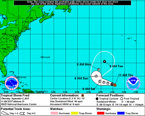
The once hurricane, the second of the 2015 season, is still kicking around out there. The good news for Florida, however, is that Fred has lost some of his punch and isn’t anticipated to head in this direction. As of 11 a.m. Thursday, Fred was located about 760 miles west-northwest of the Cape Verde Islands.
Forecasters from the National Hurricane Center anticipate Fred’s maximum sustained winds of 40 mph will start to die down soon. He’s predicted to downgrade into a tropical depression over the next day or so. Of particular good news for the coastal United States and the Caribbean, forecasters also expect Fred to take a turn to the east on Monday. Should that occur, Fred would head further out into the open waters of the Atlantic.
Find out what's happening in Clearwaterfor free with the latest updates from Patch.
While Fred’s sort of spinning in circles, forecasters are watching another disturbance that is expected to move off the west coast of Africa at some point on Thursday. That storm had a 40 percent chance of forming into a tropical cyclone over the next five days as of 8 a.m. Thursday. Forecasters anticipate the disturbance to move in a westerly direction. Whether it will form or just where it will head if it does remain too soon to call.
For a complete look at the forecast for your neighborhood, visit your local Patch’s homepage.
Find out what's happening in Clearwaterfor free with the latest updates from Patch.
Graphic courtesy of the National Hurricane Center
Get more local news delivered straight to your inbox. Sign up for free Patch newsletters and alerts.