Community Corner
Irene May Bring Strong Winds to Tampa Bay Area
The hurricane is no longer expected to make landfall in Florida, but Gulfport residents could still feel its effects starting this evening.

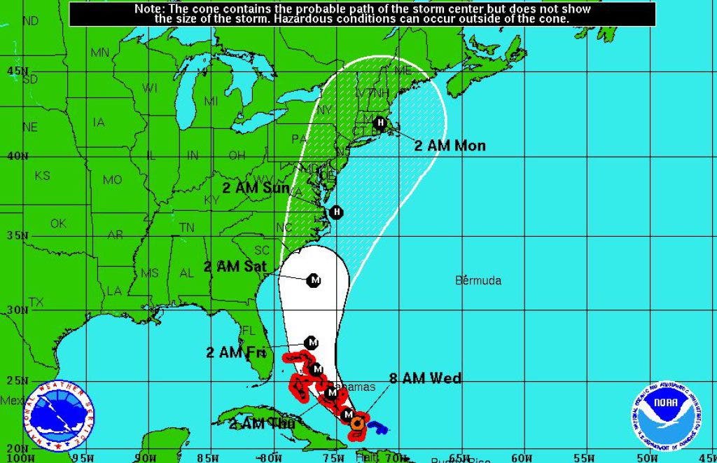

Hurricane Irene is picking up speed and strength as it turns toward the East Coast, according to the National Hurricane Center in Miami.
Irene lumbered into the Bahamas as a Category 1 hurricane Tuesday night and by this morning had ballooned into a Category 3 storm. Forecasters warn that Irene could become a Category 4 hurricane by the end of the day as it turns north.
The storm's projected path has been adjusted steadily to the east throughout the past 48 hours. Forecasters no longer expect the center of the storm to make landfall in Florida.
Find out what's happening in Gulfportfor free with the latest updates from Patch.
However, Irene could still bring rain and strong wind to the Tampa Bay area. The National Hurricane Center reports that tropical-storm-force winds extend up to 205 miles from the center of the storm. For some perspective on the storm's reach, consider that Jacksonville is about 200 miles away from Tampa.
Irene is also packing a storm surge of up to 11 feet, a figure that is expected to grow by the time the storm makes landfall in the United States on Saturday. Current forecast models from the National Hurricane Center suggest it may run aground in the Carolinas.
Find out what's happening in Gulfportfor free with the latest updates from Patch.
The local seven-day forecast from the National Weather Service is calling for scattered thunderstorms on Thursday and Friday, with wind picking up as early as tonight and gusts continuing into Saturday.
Stay with Gulfport Patch for developments on Hurricane Irene.
For more information about hurricane preparedness and local resources check out our series
Get more local news delivered straight to your inbox. Sign up for free Patch newsletters and alerts.