Weather
4 Worst Threats To South Florida From Hurricane Irma
When Hurricane Irma strikes South Florida, there are four immediate threats you must be prepared to deal with, according to forecasters.


MIAMI, FL — When Hurricane Irma strikes South Florida, there are four immediate threats that everyone must be prepared to deal with, a hurricane expert with the National Weather Service warned on Thursday afternoon. Kevin Scharfenberg said that forecasters fear South Florida could possibly see a storm surge as high as 9 feet in some places, driving rains that flood buildings, winds that turn poorly constructed structures into rubble and tornadoes that rip through entire neighborhoods. What's more, forecasters still can't be exactly sure where Irma will strike.
As of the best information available on Thursday afternoon, Scharfenberg said that South Florida will begin feeling storm-force winds on Saturday afternoon and he urged residents to plan to be wherever they intend to ride out the storm sometime on Friday night. (For more hurricane news or local news from Florida, click here to sign up for real-time news alerts and newsletters from Miami Patch, and click here to find your local Florida Patch. If you have an iPhone, click here to get the free Patch iPhone app.)
"Preparations need to be completed by the end of the day Friday," he said. "By Friday night people need to be where they plan to ride this thing out."
Find out what's happening in Miamifor free with the latest updates from Patch.
Watch: New Track Has Irma Directly Hitting South Florida
Unfortunately, Scharfenberg said it is still too early to which part of South Florida is likely to see the worst of Irma.
Find out what's happening in Miamifor free with the latest updates from Patch.
"This threat is pretty equal right now from what we can see across all of South Florida — West Coast, central and East Coast and into the Keys," he said. "So people need to be responding."
These are the four immediate threats you should be prepared to face based on the best available information as of Thursday afternoon:
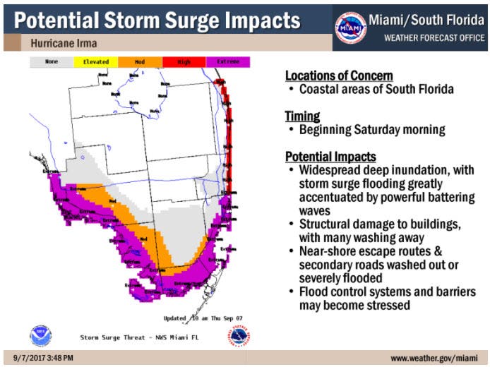
- Storm Surge: This is one of the most dangerous aspects of Hurricane Irma. "There is a possibility of wide, threatening inundation from storm surges — from sea water coming in and rising rapidly due to the storm surge," according to Scharfenberg. "You can’t rule out — and you need to be prepared for the reasonable worst case scenario of 9 feet high water due to storm surge in some of those areas above ground. So that’s another very serious life-threatening aspect to this storm for some areas." This is likely to occur anywhere along the Southwest coast of Florida from Bonita Beach southward and along the East Coast from Palm Beach and Broward Counties into Miami-Dade County. "As you get down into Miami-Dade County, the threat extends a little bit more inland, especially as you get down toward Homestead and then the Florida Keys," he said. "All of the Florida Keys are under a storm surge watch as well."
![]()
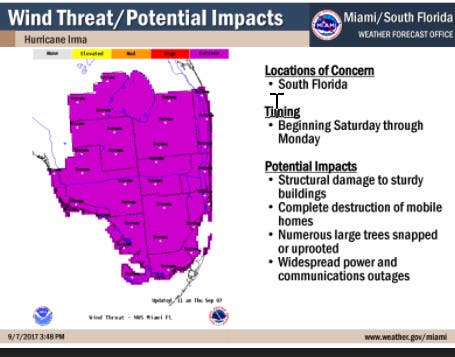
- Wind: This threat is likely everywhere in South Florida from the West Coast to the East Coast and from Lake Okeechobee south into the Florida Keys keys. He said that the danger will begin with Tropical Force winds ahead of the worst of Irma. "These are the sorts of wind impacts that can cause significant damage to structures, complete destruction of mobile homes," he explained. "It looks like a tornado went through large streets …. and widespread power and communication outages in the worst hit areas." People in mobile homes and poorly constructed buildings should plan to move to a safer location by Saturday morning.
![]()
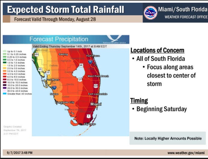
- Rain: South Florida is likely to receive 8 to 12 inches of rain during the storm with some places receiving as much as 20 inches. The greatest danger appears to be in the urban East Coast corridor but all of South Florida is vulnerable. "The rain water could enter some structures," he said. "A lot of low spots, underpasses, those poor drainage areas could become impassable pretty quickly because of rain water."
![]()
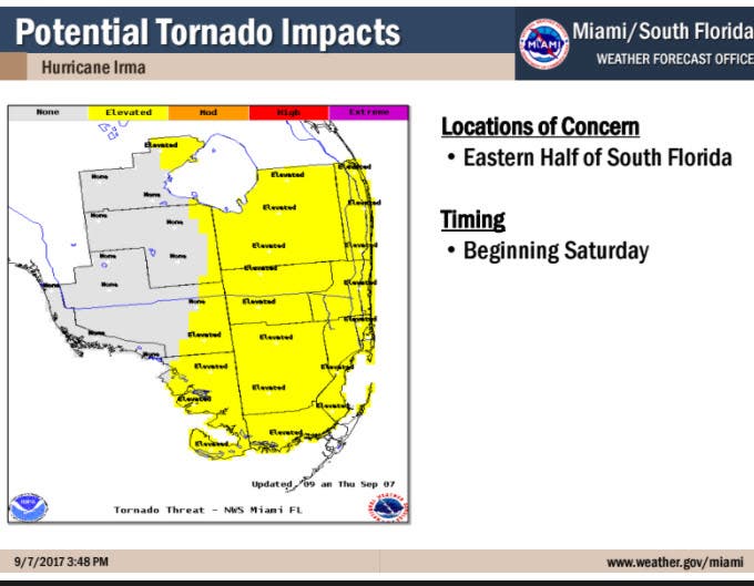
- Tornadoes: The threat of tornadoes is particularly scary for South Floridians because we don't commonly associated them with our area. We are most likely to see tornadoes in the early stages as the storm forms over South Florida. "That’s one of the reasons why we’re really telling folks to get ready by —and be where they are going to ride out the storm — by Friday night, because as we get into Saturday those outer bans will start to rotate up over south Florida and that’s a favorable situation for some tornado activity." He said that the greatest threat appears to be in the eastern half of South Florida. "That’s going to begin Saturday maybe on the front end off the storm," he explained. "That could be disruptive to folks if they try to wait until the last minute, and if they are out and about that could be a real hazard to them."
Images courtesy of the National Weather Service in Miami
Get more local news delivered straight to your inbox. Sign up for free Patch newsletters and alerts.