Weather
Tropical Storm Fred Expected To Impact Florida Starting Friday
Tropical Storm Fred officially became the sixth named storm of the Atlantic hurricane season Tuesday night.


MIAMI, FL — The weather disturbance that the National Hurricane Center has been monitoring in the Caribbean this week officially became the sixth named storm of the Atlantic hurricane season Tuesday night.
From Friday into early next week, Tropical Storm Fred is expected to dump 3 to 5 inches of rain on the Florida Keys and southeast Florida with isolated rainfall of up to 8 inches in some area, according to the hurricane center.
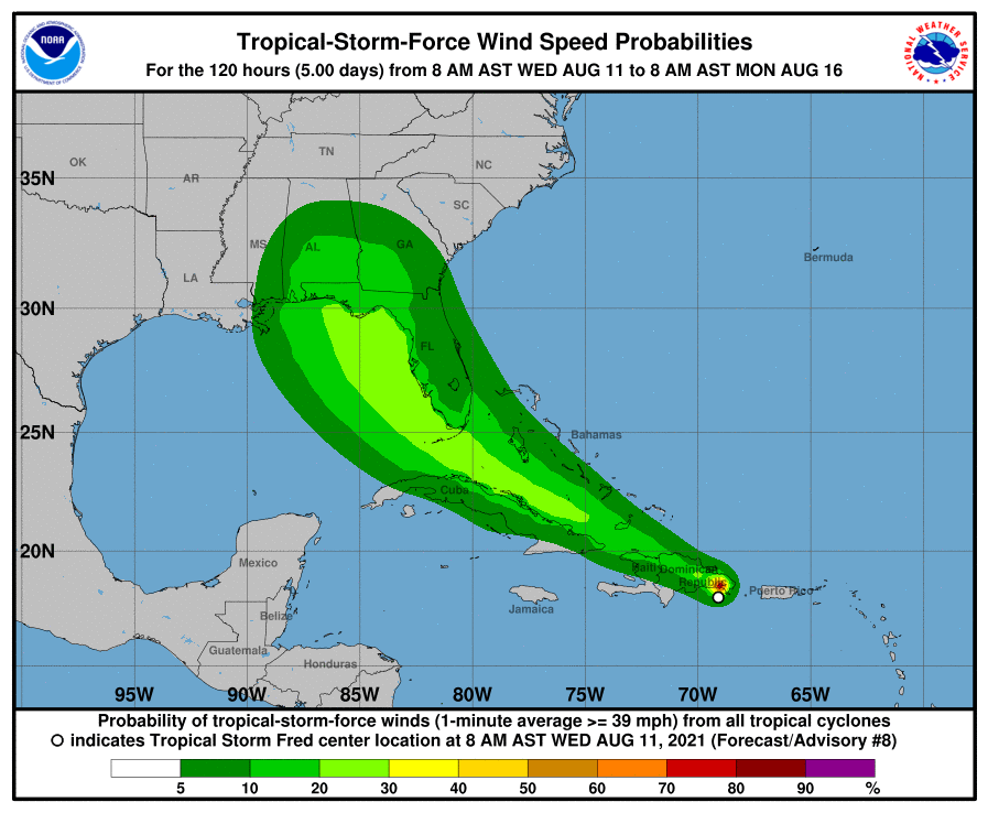
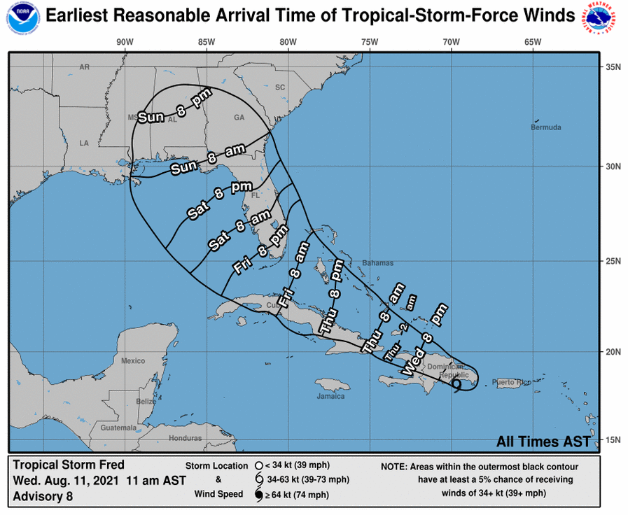
In its 11 a.m. Wednesday advisory, the hurricane center said Fred is moving west-northwest at about 16 mph, and a general west-northwestward motion with a decrease in forward speed is expected to continue for the next few days.
Find out what's happening in Miamifor free with the latest updates from Patch.
On the forecast track, the center of Fred is expected to be near or over Hispaniola Wednesday afternoon and evening, move near the Turks and Caicos Islands and the southeastern Bahamas on Thursday, and move near or north of the northern coast of central Cuba on Friday.
Stay tuned to Patch for updates on Tropical Storm Fred.
Find out what's happening in Miamifor free with the latest updates from Patch.
Fred is now producing maximum sustained winds near 45 mph with higher gusts. A weakening is expected later Wednesday as the center of Fred crosses Hispaniola. Fred will then slowly intensify beginning Thursday night.
Currently, tropical storm-force winds extend up to 60 miles, mainly to the northeast of Fred's center.
The hurricane center said it's too soon to determine the path of Fred and any potential impact to Florida. However, the current trajectory shows Fred skirting the west coast of Florida and making landfall in the Panhandle.
As Fred traverses Florida's west coast over the weekend, residents should expect heavy rainfall that may cause some urban, flash and small stream flooding along with possible rapid rise of rivers. Fred could also produce storm surge and rip tides along the west coast of the state.
A tropical storm warning is in effect for the Dominican Republic to the Haiti border. A warning means that tropical storm conditions are expected in the next 12 hours.
A tropical storm watch is in effect for Haiti, the Turks and Caicos Islands, southeastern Bahamas and Cuba.
State emergency management departments along the west coast of Florida are urging residents to have their hurricane survival kits ready.
No counties have activated their emergency management centers yet and Brooksville is the only community that has announced the opening of a sandbag station.
The National Oceanic and Atmospheric Administration has predicted a busier-than-average Atlantic hurricane center, which runs from June 1 to Nov. 30.
NOAA predicted 15 to 21 named storms, with seven to 10 becoming hurricanes.
Researchers from Colorado State University, who provides storm predictions for the season each April, revised their forecast on Aug. 5.
Researchers Philip J. Klotzbach, Michael M. Bell and Jhordanne Jones have predicted 18 named storms, up from 17 in their forecast issued in April, including the five named storms that have already occurred.
The researchers also revised their prediction from eight hurricanes, four of which will be Category 3 or higher.
“Elsa’s development and intensification into a hurricane in the tropical Atlantic also typically portends an active season,” the researchers said in their revised report. “We anticipate an above-normal probability for major hurricanes making landfall along the continental United States coastline and in the Caribbean.”
This will make 2021 the sixth straight year of an above-average Atlantic hurricane season. The record 2020 season had 30 named storms, 12 of which made landfall, including Laura and Delta, which struck southwest Louisiana.
The Colorado State forecasters also said there is a 68 percent chance a major hurricane will strike the U.S. coastline. In an average year, that number is 52 percent. They also noted a 43 percent chance for the East Coast including Florida to be hit (up from 31) and a 43 percent chance of the Gulf Coast from the Florida Panhandle to Brownsville, Texas (up from 30) of seeing a hurricane.
Those increases are based on a lack of any El Niño conditions, which typically reduce Atlantic hurricane activity.
See related stories:
Get more local news delivered straight to your inbox. Sign up for free Patch newsletters and alerts.