Weather
Remembering the Great Miami* Snowstorm — No Really
Robert Molleda of the National Weather Service explains just how Miami's first and only snowstorm may have happened.


MIAMI — Who among us can say they have never called relatives and friends up north to gloat over Miami's good weather?
It wasn't always this way as Robert Molleda of the National Weather Service points out. Miami had its very own snowstorm 40 years ago this week, or at least it earned an asterisk in the weather history books for possibly having one.
This is our wintry tale of woe.*
Find out what's happening in Miamifor free with the latest updates from Patch.
So take that good people of Boston, Chicago, Philadelphia and New York the next time you accuse Miamians of living in a one-season town.
By Robert Molleda
Find out what's happening in Miamifor free with the latest updates from Patch.
On Jan. 19, 1977, snow fell in South Florida for the first time in recorded history. Residents and visitors were both surprised and thrilled at the rare phenomena, and local newspapers ran headlines which were nearly as big as it would be for major national or world events.
News of President Jimmy Carter’s inauguration was pushed out of the headlines. Snow was seen across all of Southeast Florida as far south as Homestead and even on Miami Beach.
Snow was officially reported by weather observers in West Palm Beach, LaBelle, Hollywood and Royal Palm Ranger Station in deep south Miami-Dade County.
Reports of snow mixed with rain were even received from the Bahamas in Freeport on the other side of the Gulf Stream from Southeast Florida.
Although snow in Florida is not as rare as it is believed to be, the farthest south snow had been previously observed was along a Fort Myers to Fort Pierce line in February 1899.
The snow came on the heels of a strong Arctic cold front which moved rapidly down the Florida peninsula from late on Jan. 18 through the pre-dawn hours of Jan. 19.
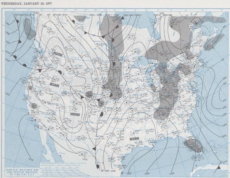
Tampa measured .20 inches and Plant City, east of Tampa, measured up to 2 inches of the white stuff. West Palm Beach reported its first snowfall on record at 6:10 a.m. and continued to report light snow through 8 a.m. LaBelle also reported snow in their cooperative observation report submitted the morning of Jan. 19.
Rain began to mix with snow over areas farther south, and eventually fell as snow flurries across Broward and Miami-Dade counties between 8 and 9:30 a.m. Miami International Airport, the official weather reporting site for Miami, did not observe the snowfall.
However, cooperative stations in Hollywood and Royal Palm Ranger Station in far southern Miami-Dade County reported a trace of snow. As a result of this, and the widespread eyewitness reports of snowfall, an asterisk is included in the official precipitation records for Miami to indicate the widespread reports of snow on the morning of Jan. 19.
It is interesting to note that although air temperatures were slightly above freezing when the snow fell, the freezing level on the morning of the 19th was at only 1,500 feet above sea level which is at a very low altitude for South Florida. This prevented the precipitation from completely melting before reaching the ground.
The snow occurred during a prolonged period of very cold temperatures in South Florida. The first arctic front moved through the region late on the afternoon of Jan. 16 with temperatures failing to reach the 60 degree mark in Miami for four consecutive days from Jan. 17-20. The coldest air and snow arrived with the second arctic front on the 19th, with the afternoon high only reaching the mid to upper 40s. Miami’s afternoon high of 47 degrees that day stands as the second coldest afternoon high on record.
The most significant impact of the frigid air was felt on the night of the 19th and morning of the 20th when winds decreased, causing temperatures to plummet to at, or below freezing virtually everywhere in South Florida, including 27 degrees at the southern tip of the Florida peninsula in Flamingo. Four locations in South Florida tied or set their all-time recorded low temperature, records which stand to this day.
Here are some of the low temperatures recorded across South Florida on the morning of Jan. 20:
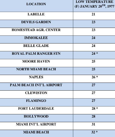
Temperatures over interior and western sections of South Florida were at or below freezing for 10 to 14 hours, and some locations were at or below 28 degrees for 4 to 8 hours.
The extended duration of freezing temperatures devastated the agricultural community in South Florida with estimated losses of $350 million statewide and over $100 million in what was then called Dade County.
Skinned fruit such as tangerines, tangelos and temple oranges were almost totally destroyed as were tender vegetables such as beans, corn, tomatoes and squash. A total of 35 counties in Florida were declared disaster areas.
Sprinklers ran all night at most farms and nurseries, and some of the water also got onto roadways, causing ice to form on some western Miami-Dade County roads and causing the Florida Highway Patrol to issue travel advisories for ice-covered roads.
Could snow fall again in South Florida?
History has already shown us that it can, and if it’s happened once, it can definitely happen again someday. In fact, there were unconfirmed reports of snow mixing with rain in South Florida on Jan. 9, 2010 from a very similar weather pattern as the one that occurred 40 years ago.
This article includes information from the original report written by Glenn E. Schwartz who worked at the National Hurricane Center in 1977. Schwartz is now a TV meteorologist in Philadelphia.
Robert Molleda is a Warning Coordination Meteorologist with the National Weather Service in the Miami/South Florida Forecast Office.
Get more local news delivered straight to your inbox. Sign up for free Patch newsletters and alerts.