Weather
Eta Could Produce Tropical-Force Winds In Florida This Weekend
The National Hurricane Center said Eta is forecast to regain tropical storm strength before it approaches southern Florida this weekend.

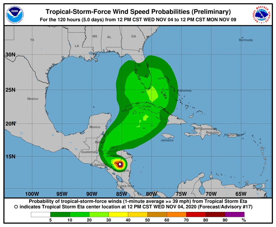
ACROSS FLORIDA — While Hurricane Eta is expected to weaken to a tropical depression in a few hours as it moves into Honduras, the National Hurricane Center in Miami said Eta is forecast to regain tropical storm strength before it approaches southern Florida this weekend.
While it is too soon to determine the exact timing, magnitude and location of possible impacts from wind and rainfall, the NHC said residents in Cuba, southern Florida and the Florida Keys should monitor the progress of Eta through the week.
While Eta is now moving westward, a mid-level ridge to the north of the cyclone should steer it on a generally west-northwestward track during the next 24 hours. After that, a mid- to upper-level trough moving over the central and eastern Gulf of Mexico is expected to cause Eta to turn northward or northwestward.
Find out what's happening in Tampafor free with the latest updates from Patch.
This could produce tropical-force winds in Florida by Sunday ranging from 64 mph in Naples, Key West and Marathon, 50 mph in West Palm Beach, Ft. Lauderdale and Venice, and 34 mph from Tampa to Panama City.
However, there are no watches or warnings in effect for Florida.
Find out what's happening in Tampafor free with the latest updates from Patch.
Miami-Dade Office of Emergency Management said Wednesday afternoon that the storm could bring heavy rainfall with localized flooding across South Florida through the end of the week and into the weekend. At this time, all Miami-Dade County services continue normal operations.
While Miami-Dade County is not in immediate danger, authorities asked residents and businesses to check their disaster kits, review their hurricane plans and remain alert to new information and instruction about the developing storm.
Specifically, residents are urged to:
- Make sure that emergency equipment, such as hurricane shutters and battery-powered radios, are in good working order;
- Ensure that sufficient emergency supplies such as non-perishable food and water are on hand for each person in the home to last at least three days;
- Obtain and store materials necessary to properly secure your home;
- Secure yard and construction debris so they do not pose a hazard during a storm;
- Take tree trimmings to a local trash and recycling center;
- Find out if you live in an evacuation zone; and
- If you live in a surge planning zone determine, in advance, where you will stay, how you will get there, and what supplies you will take if you are ordered to evacuate. Also, plan your departure so you have ample time to reach a safe area. Miami-Dade surge planning zone maps are available online at www.miamidade.gov/oem.
The 3-1-1 Contact Center hours of operation are Monday through Friday from 7 a.m. to 7 p.m. and Saturday 8 a.m. to 5 p.m. Closed on Sundays and holidays. To reach the 3-1-1 Contact Center, residents can dial 3-1-1 in Miami-Dade or (305) 468-5900 outside of Miami-Dade County. Specialists are taking calls in English, Spanish, and Creole.
Residents can access disaster-related information 24 hours a day on the OEM web site located at www.miamidade.gov/oem.
Get more local news delivered straight to your inbox. Sign up for free Patch newsletters and alerts.