Weather
FL Weather: Arctic Air To Drive Temps Down To Freezing
The National Weather Service said Florida will see the coldest weather of the season this weekend, with crops and other vegetation at risk.

FLORIDA — While a powerful nor'easter winter storm will bring heavy snow, strong winds and coastal flooding to the Northeast, the National Weather Service said Floridians should prepare for some unusually frigid temperatures in the Sunshine State this weekend.
The NWS said arctic air is expected to invade west-central Florida, bringing the coldest air of the season with some location experiencing below freezing temperatures for more than 10 hours.
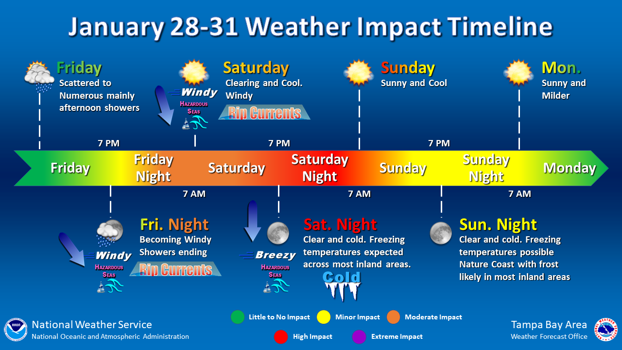
Cold temperatures are anticipated to sweep into Florida Friday with widespread lows in the 20s to low 30s Saturday night into Sunday, especially in areas east of Interstate 75 in the center of the state.
Find out what's happening in Tampafor free with the latest updates from Patch.
Counties throughout Florida have announced the opening of cold-weather shelters this weekend for homeless residents and those who have no heat in their homes. Residents needing shelter from the cold should contact their county emergency management divisions for a list of cold-weather shelters.
Meanwhile, more fortunate Floridians will be switching their thermostats from air-conditioning to heat and firing up their rarely used fireplaces to stay warm, especially in north Florida and the Suwanee Valley where a freeze watch is in effect from late Friday night through Saturday morning.
Find out what's happening in Tampafor free with the latest updates from Patch.
Areas of north and central Florida could see sub-freezing temperatures in the 20s and frost that could kill crops and other sensitive vegetation.
However, daytime temperatures will are expected to be mild, in the 40s and 50s, so events such as the annual Gasparilla Parade of Pirates shouldn't be impacted.
Here's the weather forecast for the Tampa region:
Thursday Night: Mostly cloudy, with a low around 55. North northeast wind 7 to 9 mph.
Friday: Mostly cloudy, with a high near 69. North northeast wind 5 to 7 mph becoming west northwest in the afternoon.
Friday Night: A 30 percent chance of showers, mainly between 10pm and 1am. Mostly cloudy, with a low around 44. Breezy, with a northwest wind 7 to 16 mph, with gusts as high as 21 mph.
Saturday: Sunny, with a high near 52. Wind chill values as low as 38 early. Breezy, with a north northwest wind 11 to 15 mph, with gusts as high as 24 mph.
Saturday Night: Clear, with a low around 33. North wind 6 to 9 mph.
Sunday: Sunny, with a high near 57. North northeast wind around 6 mph.
Sunday Night: Mostly clear, with a low around 39. Calm wind.
Monday: Sunny, with a high near 68. Calm wind becoming east southeast around 5 mph.
Get more local news delivered straight to your inbox. Sign up for free Patch newsletters and alerts.