Weather
Eta Forecast To Become Hurricane Before It Reaches Keys Tonight
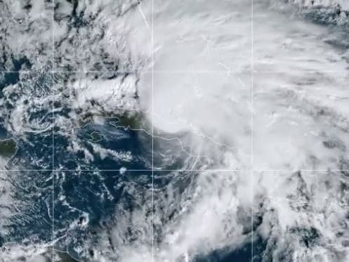
Eta is moving over the Florida Straits and is expected to produce dangerous storm surge, flash floods and strong winds in South Florida.


ACROSS FLORIDA —Tropical Storm Eta is forecast to become a hurricane before it reaches the Florida Keys tonight. Hurricane conditions are expected in the Florida Keys by early Monday morning, according to the National Hurricane Center's 1 p.m. update.
Tropical storm conditions are expected to begin in south Florida and the Florida Keys Sunday afternoon or evening, and hurricane conditions are possible in the hurricane watch area in Florida tonight and early Monday.
Tropical storm conditions are possible in the tropical storm watch area in Florida by early Monday.
Find out what's happening in Tampafor free with the latest updates from Patch.
"We expect to see tropical storm-force winds up to Central Florida, and they could be real close to hurricane strength, so you definitely have to be prepared," said NHC Director Ken Graham during a 1 p.m. news conference.
A storm surge warning is now in effect for the Florida Keys, including Florida Bay. Water levels could be as high as 2 to 4 feet above normally dry ground within the warning area, according to the National Hurricane Center.
Find out what's happening in Tampafor free with the latest updates from Patch.
Eta is moving north-northwest over the Florida Straits and is expected to produce dangerous storm surge, flash floods and strong winds over portions of Florida and the Florida Keys.
Data from satellites at 1 p.m. indicate that the center of Tropical Storm Eta was moving toward the north-northwest at 17 mph. This motion is forecast to continue through this afternoon. A turn toward the northwest is expected by this evening, followed by a westward motion by early Monday.
Once Eta reaches Florida, "it's not moving very fast," Graham said. Using computer graphics, he demonstrated Eta's slight movement west along south Florida toward the Gulf of Mexico throughout the week.
"The takeaway here is we're going to be dealing with this all week," Graham said. He said Florida will be feeling Eta's impact through Friday and possibly into next weekend.
On the forecast track, the center of Eta will continue to move over the Florida Straits between Cuba and the Bahamas this afternoon, pass near or over the Florida Keys tonight and early Monday, and be over the southeastern Gulf of Mexico late Monday and Tuesday.
At 1 p.m., Eta was about 145 miles southeast of Marathon and 170 miles south-southeast of Miami with maximum sustained winds of 65 mph with higher gusts. Some strengthening is forecast during the next 48 hours, and tropical storm-force winds could extend outward up to 125 miles from the center.
During the past few hours, tropical storm-force wind gusts have been occurring all along the southeast Florida coast. A gust of 60 mph was measured by an elevated weather station on Ft. Lauderdale Beach. A gust of 53 mph was observed at Palm Beach International Airport and at an elevated site at Fowey Rocks, while a gust of 46 mph was measured at the Boca Raton Airport. North Perry Hollywood Airport also just reported a wind gust of 53 mph.
- A storm surge warning is in effect for the Florida Keys from Ocean Reef to the Dry Tortugas, including Florida Bay.
- A storm surge watch is in effect for the Florida coast from Golden Beach to Bonita Beach, including Biscayne Bay.
- A hurricane warning is in effect for the Florida Keys from Ocean Reef to the Dry Tortugas, including Florida Bay.
- A hurricane watch is in effect for the Florida coast from Deerfield Beach to Bonita Beach.
- A tropical storm warning is in effect for the Florida coast from the Brevard-Volusia County line to Englewood including Florida Bay and Lake Okeechobee.
- A tropical storm watch is in effect for the Florida coast from north of Englewood to Anna Maria Island.
Eta is expected to produce 6 to 10 inches of rain over the central and southern Florida peninsula with isolated maximum totals of 18 inches.
"There's already 3 to 4 inches of rainfall and the ground is saturated," said Graham. "That's going to cause flooding in some areas."
Significant flash and urban flooding will also be possible for southern Florida. Minor river flooding is also possible for Central Florida.
The combination of a dangerous storm surge and the tide will cause normally dry areas near the coast to be flooded by rising waters moving inland from the shoreline.
"Storm surge is one of the deadliest factors in these storms," Graham said. "We're looking at 2 to 4 feet of storm surge from Bonita Beach to Biscayne Bay. That's very dangerous."
The water could reach the following heights above ground somewhere in the indicated areas if the peak surge occurs at the time of high tide:
- Bonita Beach to Golden Beach including Biscayne Bay 2 to 4 feet
- Florida Keys from Ocean Reef to the Dry Tortugas including Florida Bay 2 to 4 feet
- Golden Beach to Altamaha Sound, Georgia, 1 to 2 feet
The deepest water will occur along the immediate coast in areas of onshore winds, where the surge will be accompanied by large and dangerous waves. Surge-related flooding depends on the relative timing of the surge and the tidal cycle, and can vary greatly over short distances.
A tornado or two may occur this evening through Monday over south Florida and the Keys.
Swells generated by Eta are expected to affect southern Florida and the Florida Keys during the next couple of days. These swells are likely to cause life-threatening surf and rip current conditions.
A storm surge warning means there is a danger of life-threatening inundation from rising water moving inland from the coastline during the next 36 hours in the indicated locations. This is a life-threatening situation. Residents located in these areas should take all necessary actions to
protect life and property from rising water and the potential for other dangerous conditions. Promptly follow evacuation and other instructions from local officials.
A hurricane warning means that hurricane conditions are expected somewhere within the warning area. A warning is typically issued 36 hours before the anticipated first occurrence of
tropical storm-force winds, conditions that make outside preparations difficult or dangerous. Preparations to protect life and property should be rushed to completion.
A storm surge watch means there is a possibility of life-threatening inundation, from rising water moving inland from the coastline, in the indicated locations during the next 48 hours.
A hurricane watch means that hurricane conditions are possible within the watch area, in this case within the next 24 hours.
A tropical storm warning means that tropical storm conditions are expected somewhere within the warning area, generally within 36 hours.
A tropical storm watch means that tropical storm conditions are possible within the watch area, generally within 48 hours.
Get more local news delivered straight to your inbox. Sign up for free Patch newsletters and alerts.