Weather
FL Severe Weather: Strong Storms, Tornadoes Possible, NWS Says
A storm system moving in from the Gulf could bring strong winds, severe thunderstorms, heavy rains, tornados, flooding to parts of Florida.

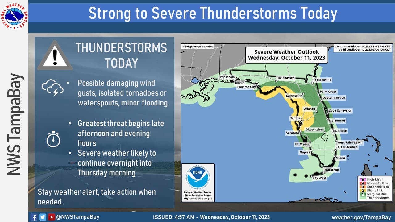
FLORIDA — A low-pressure system moving in from the Gulf of Mexico could bring severe thunderstorms, strong winds, heavy rainfall, minor coastal flooding, and threats of tornadoes and waterspouts to much of Florida Wednesday afternoon into Thursday morning.
The quick-moving storm, pulling northeastward, will bring waves of tropical moisture from both the Gulf and the East Pacific, including remnants of Hurricane Lidia, which made landfall as a Category 4 storm Monday in Mexico, according to AccuWeather.
The storm system is expected to bring showers and thunderstorms across the U.S. Gulf Coast, particularly the central and eastern parts, from Texas to southern Florida. Certain areas could see heavy downpours for at least 12 hours in some areas.
Find out what's happening in St. Petefor free with the latest updates from Patch.
The severe weather could include damaging winds of 60 to 70 mph, isolated tornadoes and waterspouts, the National Weather Service said. Forecasts said storms are most likely from late Wednesday afternoon into the evening, but severe weather may linger overnight.
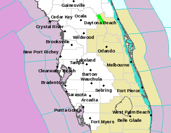
No active watches or warning were issued for the Tampa-St. Pete area as of 1:30 p.m.
Find out what's happening in St. Petefor free with the latest updates from Patch.
Forecasters had been eyeing the system for possible development into a tropical storm.
"Whether or not an organized tropical system develops, many of the impacts will remain the same," Alex DaSilva, a forecaster with AccuWeather, said.
Much of western central Florida and parts of the coastal Panhandle should expect about one to two inches of rain, forecasters said. And some areas could see isolated rain totals of three or four inches.
“Could see a few feisty storms later this evening and overnight,” Denis Phillips, meteorologist for ABC Action News, wrote in a Facebook post. “Best chances are north of I-4.”
While the Tampa Bay area saw light showers and cloud cover Wednesday morning, more hazy, warm and humid weather will develop in the afternoon, he wrote. “We'll see storms approach this evening from the Gulf and a couple could develop overhead. Any of these may be strong to severe with the potential for isolated damaging wind gusts or waterspouts/tornadoes.”
Though Florida enjoyed cooler weather over the weekend, a warm front has since moved in, increasing the chances for showers and thunderstorms mid-week, Austen Flannery, a meteorologist with the National Weather Service’s Tampa Bay office said in a video update shared Tuesday on social media.
This warm front will last into the weekend, when another cold front comes through, he said.
The storms will continue overnight into Thursday, when the region could see wind gusts as high as 28 mph, the NWS said. Scattered showers and thunderstorms are expected in the area through Saturday as the system moves into the Atlantic Ocean.
As the storm moves across the state, flash flooding could be an issue in some areas late night Wednesday and early Thursday.
Some of the rain will be heavy at times, so there are concerns for flash flooding later Wednesday and again Thursday.
"All the moisture that's in Texas and specifically that's offshore, which is where the heaviest rain is, it's going to be pushing into Florida today," Fox Weather meteorologist Britta Merwin said. "And by later tonight through tomorrow, we could have a flooding concern."
Get more local news delivered straight to your inbox. Sign up for free Patch newsletters and alerts.