Weather
Flood Watch Issued, 5 Inches Of Rain Expected In GA
See which areas will undergo a flood watch due to storms and around 5 inches of expected rainfall in Georgia.

A flood watch was issued on Wednesday for portions of Georgia as forecasters predict around 5 inches of rain in the state's northern region.
A stalled frontal boundary could conjure repeated rounds of storms in some areas, and "an anomalously moist environment" could promote increased rain rates and flash flooding, according to the National Weather Service.
Forecasters predicted widespread rainfall amounts of 2-4 inches and locally higher amounts of at least 5 inches.
Find out what's happening in Cartersvillefor free with the latest updates from Patch.
"Interplay between moisture streaming off of Tropical Storm Bertha and a stalling frontal boundary will support training showers and thunderstorms across north Georgia, leading to heightened chances for localized flash flooding," the NWS stated.
The agency issued the flood watch for the following counties: Dade, Walker, Catoosa, Whitfield, Murray, Fannin, Gilmer, Union, Towns, Chattooga, Gordon, Pickens, Dawson, Lumpkin, White, Floyd, Bartow, Cherokee, Forsyth, Hall, Banks and Polk.
Find out what's happening in Cartersvillefor free with the latest updates from Patch.
This impacts Cartersville, Cumming, Woodstock, Gainesville and other local towns.
The flood watch will go into effect at 8 p.m. Wednesday and will last through Friday night.
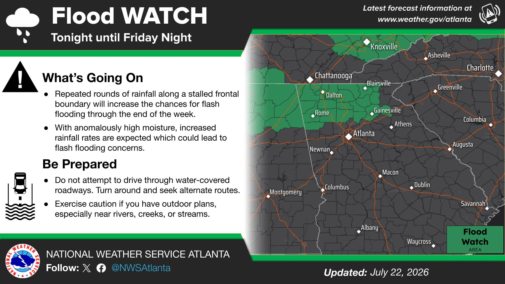
In other areas, several showers and thunderstorms could arise in Wednesday afternoon into nightfall. The NWS reported these storms could continue into the weekend.
The stronger storms could produce heavy rainfall, localized flash flooding, frequent lightning and gusty winds, according to the NWS.
The Georgia Emergency Management and Homeland Security Agency offers online flooding and flash flooding tips.
RELATED:
- Tropical Storm Bertha Forms; Flash Flood Risks Arise In GA
- Possible Tropical Storm Brewing In Gulf: What To Know In GA
.png)
Here is the National Weather Service's Wednesday afternoon forecast for metro Atlanta:
This Afternoon: Partly sunny, with a high near 90. Heat index values as high as 98. South wind around 10 mph, with gusts as high as 20 mph.
Tonight: A 20 percent chance of showers and thunderstorms before 1 a.m. Mostly cloudy, with a low around 75. South wind 5-10 mph, with gusts as high as 15 mph.
Thursday: A 30 percent chance of showers and thunderstorms after 2 p.m. Partly sunny, with a high near 89. Heat index values as high as 97. Southwest wind 5-10 mph, with gusts as high as 15 mph.
Thursday Night: Showers and thunderstorms likely before 4 a.m., then a chance of showers between 4 a.m. and 5 a.m., then a chance of showers and thunderstorms after 5 a.m. Mostly cloudy, with a low around 73. West wind around 5 mph becoming calm in the evening. Chance of precipitation is 60 percent.
Friday: Showers and possibly a thunderstorm. High near 87. West wind around 5 mph. Chance of precipitation is 80 percent.
Friday Night: Showers and thunderstorms before 11 p.m., then a chance of showers. Low around 73. Chance of precipitation is 80 percent.
Saturday: Showers and thunderstorms likely, mainly after 2 p.m. Mostly cloudy, with a high near 87. Chance of precipitation is 70 percent.
Saturday Night: Showers and thunderstorms likely before 2 a.m., then a slight chance of showers. Partly cloudy, with a low around 73. Chance of precipitation is 60 percent.
Sunday: A slight chance of showers, then a chance of showers and thunderstorms after 8 a.m. Mostly sunny, with a high near 90. Chance of precipitation is 30 percent.
Sunday Night: A 30 percent chance of showers and thunderstorms before 8 p.m. Mostly clear, with a low around 75.
Monday: Sunny, with a high near 93.
Monday Night: Mostly clear, with a low around 76.
Tuesday: A 20 percent chance of showers and thunderstorms. Sunny, with a high near 94.
Get more local news delivered straight to your inbox. Sign up for free Patch newsletters and alerts.