Weather
'Frigid' Nights, Snow Showers To Hit Chicago Area
Wind chills on Friday night and Saturday night will be in the single-digits or even below zero.

ILLINOIS — Cold temperatures will move into the area for the weekend, and highs in the low 30s as well as "frigid" nights are expected on Friday and Saturday, according to the National Weather Service.
Scattered flurries are possible throughout the day on Friday, and the high for the day is only 27 degrees. Friday night will feature single-digit wind chills, according to the weather service.
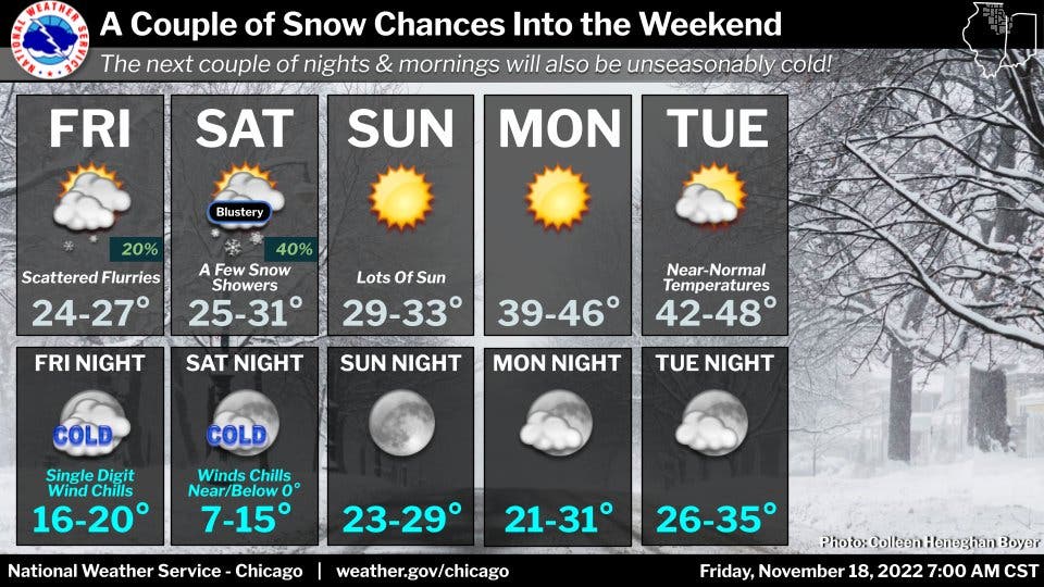
Saturday could also see a few snow showers, the weather service said. Most areas will only see flurries, but a few areas affected by snow showers could see reduced visibility, and nearly an inch of snow.
Find out what's happening in Across Illinoisfor free with the latest updates from Patch.
It will be blustery, with a high of 31 degrees. Saturday night will again be cold, with wind chills near or below zero, according to the weather service.
AccuWeather also called for "a few flurries in the afternoon" on Saturday. The private forecaster also said Saturday night will be "bitterly cold."
Find out what's happening in Across Illinoisfor free with the latest updates from Patch.
Snow isn't expected Sunday, which will be sunny with a high of 33 degrees, according to the weather service.
Temperatures will start to return to normal by the start of the work week. Monday will have a high of 46, and Tuesday a high of 48 degrees, according to the weather service.
Get more local news delivered straight to your inbox. Sign up for free Patch newsletters and alerts.