Weather
‘Heavy Downpours,’ Storms Could Hit As Spring Starts In IL
Rainy weather is expected throughout the week, with a high of 61 possible on Thursday.

ILLINOIS — The first day of astronomical spring on Monday will bring rain, blustery winds and an elevated risk of fire spread for near and southeast of Interstate 55, according to the National Weather Service.
This week will bring "typical early spring weather," the weather service said.
Monday will have a high of 53 degrees, and gusty winds and a dry air mass could increase fire spread risk during the afternoon, according to the weather service.
Find out what's happening in Across Illinoisfor free with the latest updates from Patch.
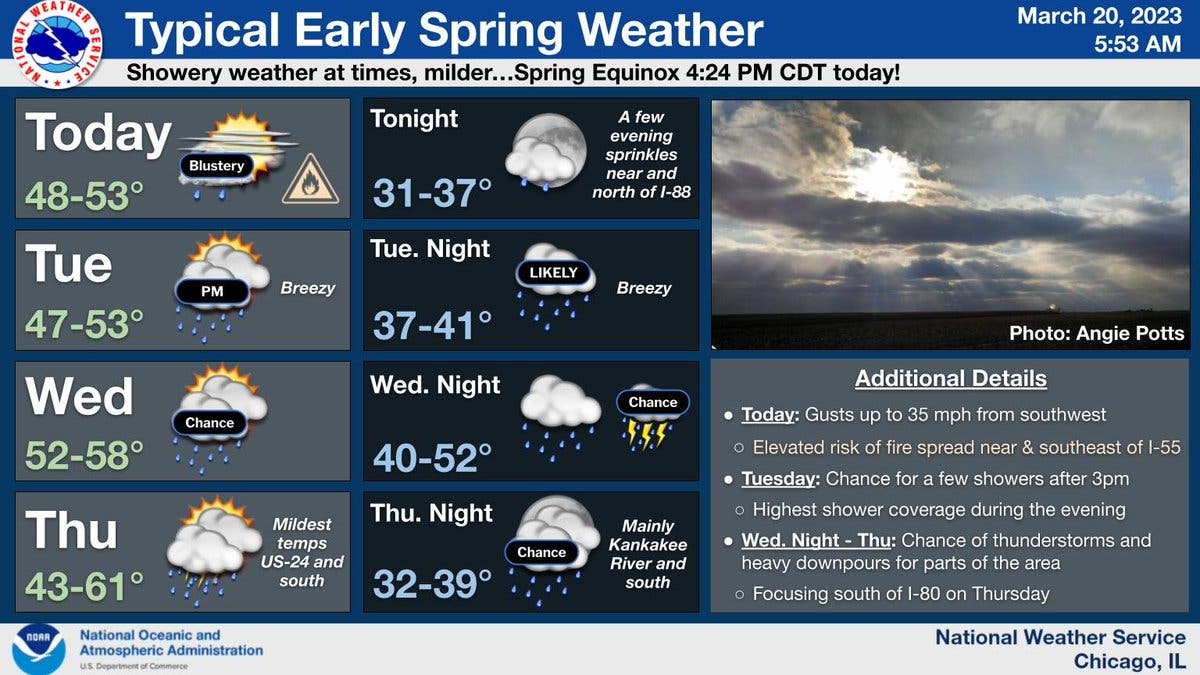
Tuesday will have a high of 53 degrees, and will be breezy with rain expected in the afternoon. The weather service said rain could be possible Tuesday afternoon through Thursday.
Find out what's happening in Across Illinoisfor free with the latest updates from Patch.
Temps will be even warmer on Wednesday, with a high of 58 degrees expected. However, there is a chance of thunderstorms and heavy downpours for parts of the area Wednesday night into Thursday, according to the weather service.
Thursday will be the warmest day of the week, as a high of 61 degrees is possible. The mildest temperatures will be more toward central Illinois, according to the weather service.
AccuWeather forecasted a high of 50 degrees for Joliet on Thursday and that .17 inches of rain is possible.
Friday will be cooler again, with a high of 44 degrees. There is a chance of rain in the afternoon, and a chance of rain and snow on Friday night, the weather service said.
Get more local news delivered straight to your inbox. Sign up for free Patch newsletters and alerts.