Weather
Severe Storms Could Hit As Cold Front Moves Into Chicago Area
The biggest threat of severe weather comes Wednesday night, with potential for 65 mph winds and damaging hail.

ILLINOIS — Storms are possible Wednesday evening as the Chicago area remains under an excessive heat warning, according to the National Weather Service. Storms could bring gusty winds up to 65 mph and damaging hail.
AccuWeather forecasts a high of 93 degrees Wednesday for Chicago, with a 72 percent chance of thunderstorms Wednesday night.
Storms are expected to develop ahead of a cold front across northern Illinois on Wednesday evening, according to the weather service.
Find out what's happening in Across Illinoisfor free with the latest updates from Patch.
Find out what's happening in Across Illinoisfor free with the latest updates from Patch.
The weather service said a broken line of storms will move across the area Wednesday night, with a severe weather threat the greatest through the mid-evening. Severe weather is most likely north and west of the Interstate 55 corridor through midnight.
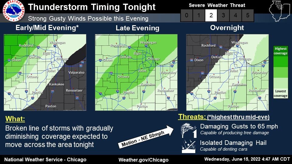
Storm coverage will decrease farther east into northwest Indiana later Wednesday, with the threat of severe weather also diminishing.
Wednesday will remain hot and humid before the cold front moves in, with breezy and less-humid weather Thursday and highs between 87 and 93 degrees.
Dry and seasonably warm weather is expected Friday through the weekend.
Get more local news delivered straight to your inbox. Sign up for free Patch newsletters and alerts.