Weather
Severe Storms Possible Thursday, Cold Temperatures To Return To Chicago Area
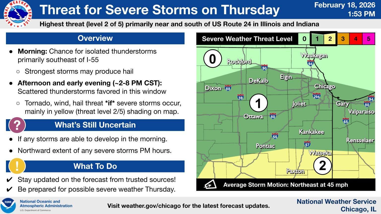
Here's what time to expect severe weather.

Scattered storms are possible Thursday afternoon, with a chance for severe storms, according to the National Weather Service.
The weather service said there is a limited thunderstorm risk, with a risk of damaging winds and large hail. Storms are expected between 2 and 8 p.m. Thursday.
"Some of these storms could be strong to severe, particularly across central Illinois and Indiana," the weather service said.
Find out what's happening in Across Illinoisfor free with the latest updates from Patch.
The high for Thursday is 61 degrees, but colder temperatures will return to close out the week, according to the weather service. Friday will have a high of 42, and there is even a chance for a rain and snow mix.
Highs in the 40s and 30s are then expected for the weekend, with a high of 40 on Saturday, and a high of 34 on Sunday, according to the current forecast.
Find out what's happening in Across Illinoisfor free with the latest updates from Patch.
Here is a more detailed look at the weather through the weekend, per the weather service:
THURSDAY: A slight chance of showers before 3 p.m., then a chance of showers and thunderstorms between 3 p.m. and 5 p.m., then showers likely and possibly a thunderstorm after 5 p.m. Mostly cloudy, with a high near 55. East northeast wind 5 to 10 mph, with gusts as high as 20 mph. Chance of precipitation is 60%. New rainfall amounts of less than a tenth of an inch, except higher amounts possible in thunderstorms.
THURSDAY NIGHT: Showers and possibly a thunderstorm before 3am, then a chance of showers. Low around 34. Breezy, with an east northeast wind 10 to 15 mph becoming west 15 to 20 mph after midnight. Winds could gust as high as 35 mph. Chance of precipitation is 80%. New precipitation amounts between a tenth and quarter of an inch, except higher amounts possible in thunderstorms.
FRIDAY: A chance of rain and snow before 7 a.m., then a chance of snow between 7 a.m. and noon. Mostly cloudy, with a high near 41. Breezy, with a west wind 15 to 25 mph, with gusts as high as 40 mph. Chance of precipitation is 30%.
FRIDAY NIGHT: Partly cloudy, with a low around 27. West wind 10 to 15 mph, with gusts as high as 25 mph.
SATURDAY: Partly sunny, with a high near 38. West northwest wind around 10 mph, with gusts as high as 15 mph.
SATURDAY NIGHT: A 20 percent chance of snow after midnight. Mostly cloudy, with a low around 25.
SUNDAY: A 20 percent chance of snow before noon. Mostly cloudy, with a high near 34.
SUNDAY NIGHT: Mostly cloudy, with a low around 20.
Get more local news delivered straight to your inbox. Sign up for free Patch newsletters and alerts.