Weather
Severe Storms Possible Tuesday, Wednesday; Temps In The 70s For Chicago Area
The week starts off dry and sunny, before severe storm chances mid-week.

Temperatures in the 70s are expected all week, as severe storms are possible mid-week, according to the National Weather Service.
The renewed storm chances come days after severe storms, including tornadoes and a derecho, slammed the Chicago area, leaving over 170,000 without power.
Monday will have a high of 76 degrees, and it should be dry and sunny all day.
Find out what's happening in Across Illinoisfor free with the latest updates from Patch.
"There will be a chance of showers and thunderstorms Tuesday," the weather service said on its Facebook. "A few of these storms may become severe."
Tuesday has a high of 76 degrees as well. The greatest coverage of any storms will be east of Interstate 39. According to the weather service, the strong to severe storm threat will be from 2 to 7 p.m.
Find out what's happening in Across Illinoisfor free with the latest updates from Patch.
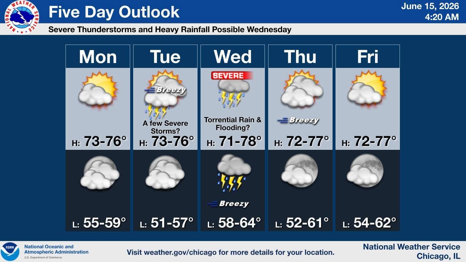
Wednesday has a high of 78 degrees, and again, storms are possible.
The weather service said storms with all severe hazards are possible on Wednesday, as well as heavy rain and localized flooding.
"It is still a couple days away and the precise hazards and greatest threat areas may shift some," the weather service on its Facebook.
Weather should dry out for the rest of the week, with a high of 77 degrees on Thursday and Friday.
Here is a more detailed look at the weather this week, per the weather service:
MONDAY: Increasing clouds, with a high near 74. West wind 5 to 10 mph, with gusts as high as 20 mph.
MONDAY NIGHT: Partly cloudy, with a low around 57. South southwest wind 5 to 10 mph, with gusts as high as 15 mph.
TUESDAY: Showers and thunderstorms likely before 4 p.m., then showers and possibly a thunderstorm between 4 p.m. and 5 p.m., then a chance of showers and thunderstorms after 5 p.m. High near 74. Breezy, with a south southwest wind 10 to 20 mph, with gusts as high as 30 mph. Chance of precipitation is 80%. New rainfall amounts between a tenth and quarter of an inch, except higher amounts possible in thunderstorms.
TUESDAY NIGHT: A chance of showers and thunderstorms before 7 p.m., then a slight chance of showers between 7 p.m. and 1 a.m. Mostly clear, with a low around 53. West wind 5 to 15 mph, with gusts as high as 20 mph. Chance of precipitation is 30%.
WEDNESDAY: A chance of showers before 10 a.m., then a chance of showers and thunderstorms between 10 a.m. and 1 p.m., then showers and possibly a thunderstorm after 1 p.m. Some of the storms could produce heavy rainfall. High near 74. Breezy, with a south southeast wind 5 to 10 mph increasing to 15 to 20 mph in the afternoon. Winds could gust as high as 30 mph. Chance of precipitation is 90%.
WEDNESDAY NIGHT: Showers and possibly a thunderstorm before 1 a.m., then a slight chance of showers. Low around 61. Breezy. Chance of precipitation is 90%.
THURSDAY: Mostly sunny, with a high near 73. Breezy.
THURSDAY NIGHT: Partly cloudy, with a low around 55.
FRIDAY: Sunny, with a high near 74.
FRIDAY NIGHT: Mostly clear, with a low around 56.
Get more local news delivered straight to your inbox. Sign up for free Patch newsletters and alerts.