Weather
2 To 5 Inches Of Snow Possible For IL As Winter Weather Advisory Issued
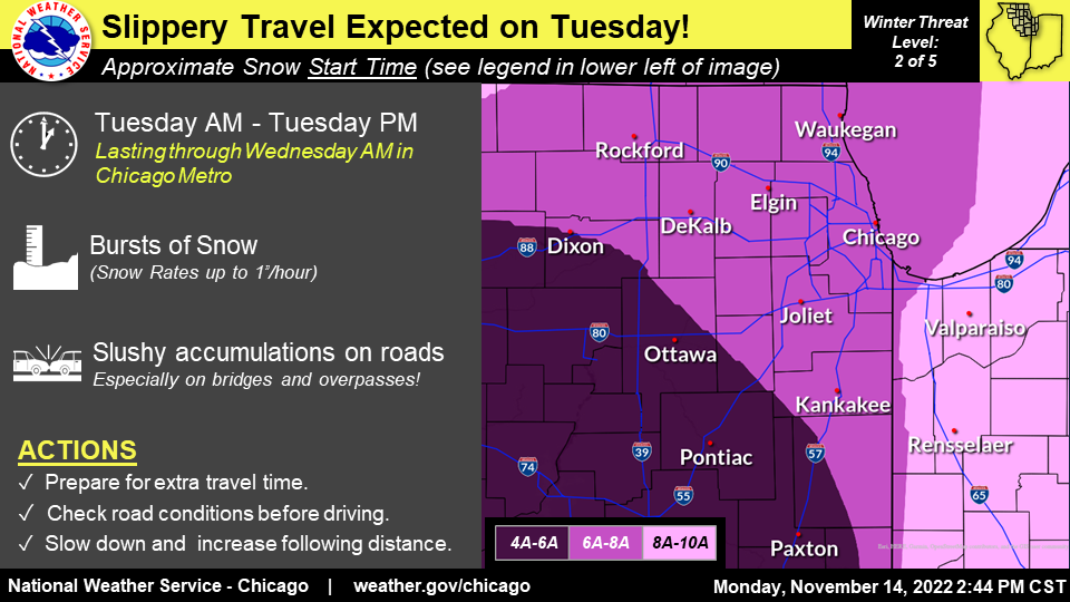
The National Weather Service has issued a winter weather advisory in preparation of the snow headed into the area on Tuesday.


ILLINOIS — The warm temperatures are gone, and wintry weather is making its entrance to the Chicago area — and it's about time to get out those snow shovels, as the first measurable snowfall of the season is likely to be more than a dusting.
"Winter arrives this week," the National Weather Service proclaimed, although the first official day of winter on Dec. 21 is more than a month away.
The National Weather Service has issued winter weather advisories across the Chicago area in preparation of the snow headed into the area Monday night and early Tuesday. The heaviest snow could come between 6 and 8 a.m. Tuesday.
Find out what's happening in Across Illinoisfor free with the latest updates from Patch.
The advisory for Central Cook, DuPage, Lake, McHenry and Northern Cook is in place until 6 a.m. Wednesday. An advisory for eastern Will, Grundy and southern Will is in effect until noon Tuesday, while the advisory for Kane, Kendall and northern Will lasts until noon Wednesday.
Accumulations will vary across the area, with 2 to 5 inches of snow expected for DuPage, McHenry and northern and central Cook County. Will, Kane and Kendall County may see 1 to 3 inches of snow, according to the advisory.
Find out what's happening in Across Illinoisfor free with the latest updates from Patch.
According to the National Weather Service, snow is expected Monday night through Wednesday. Monday will be slightly warmer than the rest of the week, with a high of 44 degrees.
Snow will begin Monday night, and some light accumulations are likely and could result in slick roads for the Tuesday morning commute, according to the weather service.
Bursts of snow could bring up to an inch per hour, with slushy accumulation on the roads.
Snow will continue on Tuesday, but the warming temps will limit accumulations on the roads in the afternoon, the weather service said. Tuesday has a high of 38 degrees.
Snow will continue on Tuesday night and into Wednesday, and scattered snow showers are expected Wednesday afternoon and evening, the weather service said. Heavier snow showers could bring reduced visibility and some localized accumulation.
AccuWeather also called for an inch or two of snow from Monday night through Wednesday afternoon.
In the private forecaster's wintercast, it gave a 1 percent chance of snow greater than 4 inches, a 20 percent chance for snow between 2 and 4 inches, and a 51 percent chance of an inch or two of snow.
Snow is still possible on Thursday, when there is a chance of flurries in the morning and snow showers in the afternoon, according to the weather service. The high for the day is 34 degrees.
Friday looks to be partly sunny, but chillier than the rest of the work week, with a high of 24 degrees.
The weather service said "much colder temperatures" are expected for the weekend, and wind chills could be in the single digits to near zero.
Get more local news delivered straight to your inbox. Sign up for free Patch newsletters and alerts.