Weather
Spring Storms, Then Snow Poised To Hit Chicago Area: Timeline For Wild Weather
Meanwhile, a blizzard warning was in place in other parts of Illinois. Here's when Sunday's severe weather is expected to hit.

Expect some weather whiplash Sunday, with high temperatures near 60 degrees giving way to possible storms, wind gusts over 50 mph, and, eventually, accumulating snow.
According to the National Weather Service, a broken line of showers and storms will initially move through northern Illinois through noon Sunday, with the risk of thunderstorms north of I-55 and scattered showers for the surrounding area.
But it won't end there. Waves of showers and storms are expected throughout the day, with the threat of damaging thunderstorm winds primarily between 4 and 9 p.m.
Find out what's happening in Across Illinoisfor free with the latest updates from Patch.
Storm risks include lightning strikes and small hail up to nickel-size, while those experiencing showers could see downpours leading to slowed driving and gusty winds that could topple small branches or move light objects.
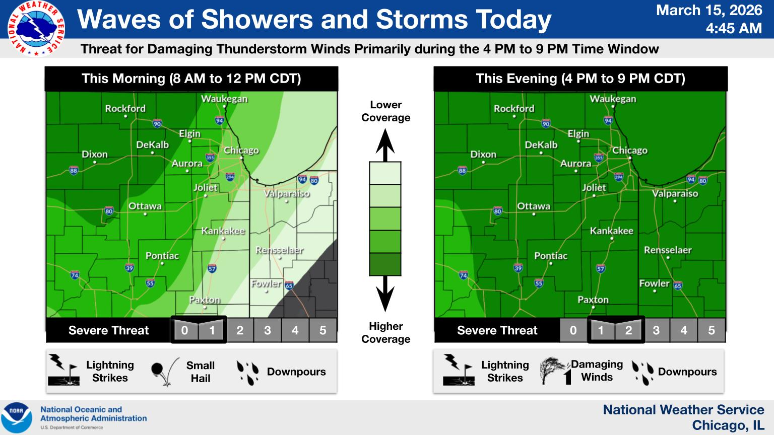
Damaging winds possible
A wind advisory is in effect for DuPage, Kane, Kendall, Lake and Cook counties from 1 to 9 p.m. Sunday. That includes Evanston, Palatine, Downers Grove, Aurora, Wheaton, Des Plaines, Naperville, Northbrook, Oak Lawn, Oswego, Buffalo Grove, Yorkville and La Grange.
Find out what's happening in Across Illinoisfor free with the latest updates from Patch.
The National Weather Service warns of peak wind gusts that could reach over 50 mph in most of the Chicago area, cautioning that new wind advisories may be needed later in the day.
Drivers should take care when driving in open and exposed areas, especially on west-to-east roadways, and residents should secure loose outdoor objects.
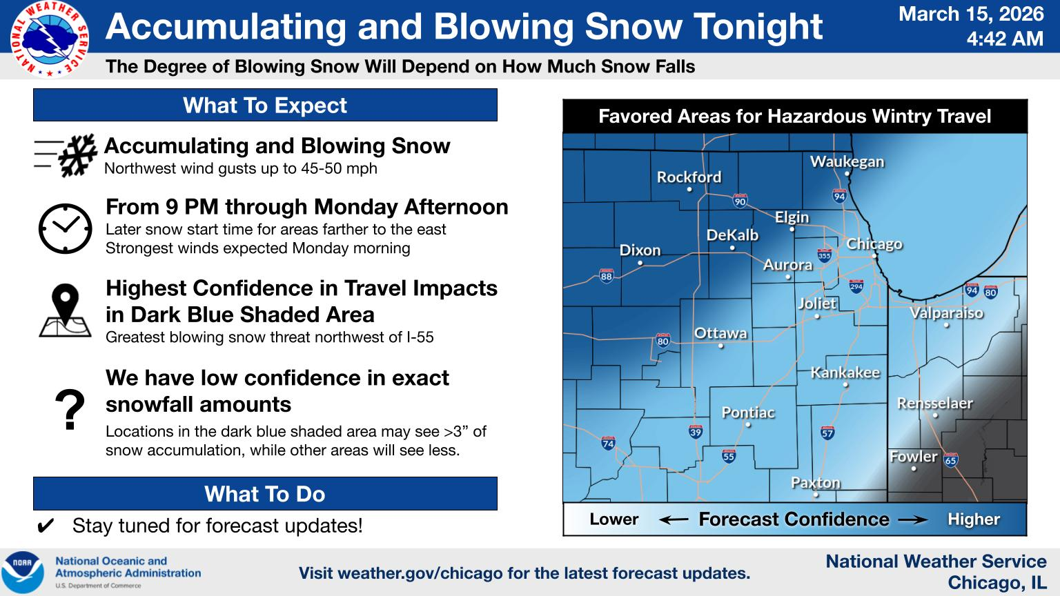
Snow expected overnight
A winter weather advisory will be in effect for DeKalb, DuPage, Kane, Kendall, Lake, McHenry and northern Cook counties from 10 p.m. Sunday to 1 p.m. Monday, with total snow accumulations of 1 to 3 inches, although some areas could see more snow accumulation.
The advisory is in effect for cities including Evanston, Palatine, Downers Grove, Aurora, Naperville, Wheaton, Des Plaines, Crystal Lake, Oswego and Algonquin.
The National Weather Service said snow and blowing snow are expected, with wind gusts up to 45 mph.
Roads, and especially bridges and overpasses, will likely become slick and hazardous, and blowing snow will result in reduced visibility and make travel hazardous at times through the Monday morning commute. Gusty winds could bring down tree branches, NWS said.
Blizzard warning for other parts of Illinois
Meanwhile, a blizzard warning is in effect from 10 p.m. Sunday to 1 p.m. Monday for Knox and Stark counties, including the cities of Toulon and Galesburg.
While total snow accumulations are expected to be between 2 and 3 inches, blizzard conditions with wind gusts up to 50 mph are expected.
Residents were told to "plan on slippery road conditions" and blowing snow that could reduce visibility to a quarter-mile or less, as well as gusty winds that can bring down tree branches.
"Travel should be restricted to emergencies only," NWS warned residents. "If you must travel, have a winter survival kit with you. If you get stranded, stay with your vehicle."
Get more local news delivered straight to your inbox. Sign up for free Patch newsletters and alerts.