Weather
Tornado Watch Issued For Chicago Area
Strong tornadoes, up to an EF-2 or higher, are possible, NWS said.

The National Weather Service has issued a tornado watch for the Chicago area.
The following counties are under a watch until 9 p.m. Thursday: Adams, Boone, Brown, Bureau, Carroll, Cass, Cook, DeKalb, De Witt, DuPage, Ford, Fulton, Grundy, Hancock, Henderson, Henry, Iroquois, Jo Daviess, Kane, Kankakee, Kendall, Knox, Lake, La Salle, Lee, Livingston, Logan, Marshall, Mason, McDonough, McHenry, Mclean, Menard, Mercer, Morgan, Ogle, Peoria, Pike, Putnam, Rock Island, Sangamon, Putnam, Rock Island, Sangamon, Schuyler, Scott, Stark, Stephenson, Tazewell, Warren, Whiteside, Will, Winnebago and Woodford.
A high wind warning has also been issued for Cook, DuPage, Grundy, Kane, Kendall and Will counties until 4 p.m.
Find out what's happening in Across Illinoisfor free with the latest updates from Patch.
The weather service said strong non-thunderstorm "wake low" winds have developed behind the first round of storms. Damaging winds are possible for the next one or two hours, and could cause widespread power outages.
RELATED: Ground Stops Delay Over 800 Flights At O'Hare, Midway Due To Thunderstorms
Find out what's happening in Across Illinoisfor free with the latest updates from Patch.
Severe weather is expected Thursday across the Chicago area, bringing a threat of strong (EF-2+) tornadoes, according to the National Weather Service.
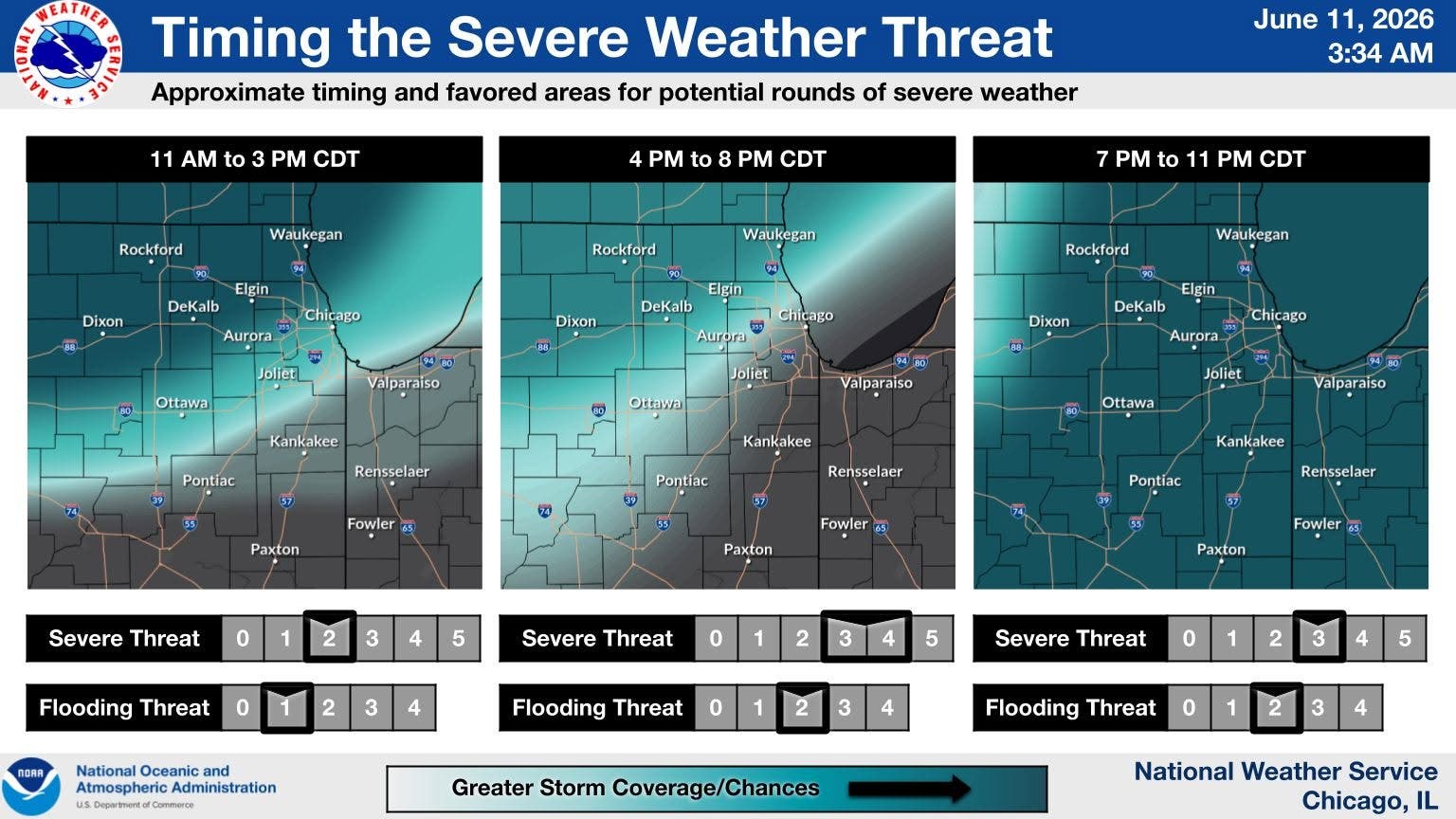
There are two rounds of severe storms possible Thursday, the weather service said. The first round is between 11 a.m. to 3 p.m. with a threat of destructive winds and hail.
The second round of storms could bring the threat of strong tornadoes and destructive winds. The weather service said this second round will be between 4 and 11 p.m. Thursday.
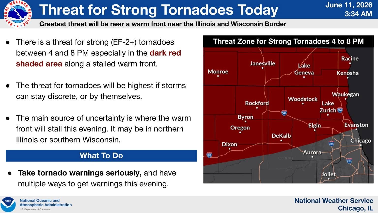
The weather service said there is still uncertainty where the warm front will stall on Thursday evening. The forecast currently has it making toward the Wisconsin state line, but it could be as far south as Interstate 80.
There is a level 3 of 5 tornado risk, a 3 out of 5 damaging wind risk, and a 2 out of 5 large hail risk with Thursday's storms.
Instances of flash flooding may also occur where storms repeatedly hit the same area, the weather service said.
Residents are advised to have several ways to receive weather alerts and to take tornado warnings seriously.
The additional severe weather comes after Wednesday night storms that have left more than 170,000 customers without power, according to ComEd.
"Based on the history of similar storms of this size, across the ComEd service area, we expect 80 percent of outages to be restored" by 11 p.m. on Saturday, ComEd said.
Get more local news delivered straight to your inbox. Sign up for free Patch newsletters and alerts.