Weather
Winter Storm Warnings Issued For Chicago Area, 'Bomb Cyclone' Possible
A flash freeze is possible Thursday, as temps could drop 20 to 30 degrees in just a few hours. Plus, here's how much snow we could get.


ILLINOIS — Winter storm watches have shifted earlier in some places in the Chicago area as a "significant winter storm" approaches, according to the National Weather Service.
Since Tuesday's forecast, an earlier arrival of dangerous travel conditions is now expected on Thursday morning as opposed to Thursday evening. The storm will move in from mid-morning through mid-afternoon from west to east.
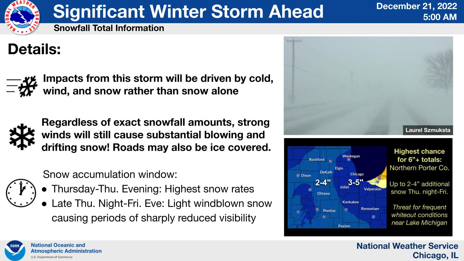
The highest snowfall rates are expected Thursday morning through Thursday evening, with windblown snow causing sharply reduced visibility Thursday night through Friday night.
Find out what's happening in Across Illinoisfor free with the latest updates from Patch.
The weather service has issued a winter storm warning for the entire Chicago area, which goes into effect at varying times depending on where you live, but ends at 6 a.m. Saturday.
"Brutal" travel conditions are anticipated, the weather service said. Blizzard conditions are possible as total snow accumulation of 3 to 5 inches is expected in most of the Chicago area.
Find out what's happening in Across Illinoisfor free with the latest updates from Patch.
AccuWeather forecasted 4 to 8 inches of snow for Chicago, with a 76 percent probability for that range, adding, "The result of both snow and wind will be nothing short of blizzard conditionsin many Midwestern states including Illinois, Indiana, Michigan, Ohio, Wisconsin, Iowa, Kansas, Nebraska and Missouri."
AccuWeather said the storm will evolve into a bomb cyclone — which is when a storm undergoes bombogenesis, or rapid strengthening and allows the barometric pressure of the storm to fall at least 0.71 of an inch in 24 hours — as it produces blizzard conditions in the Midwest.
Dangerous cold temperatures with wind chill values of 25 to 35 below zero are also expected, according to the weather service. Frostbite can occur in as little as 10 to 20 minutes at those temperatures, the weather service said.
The weather service said on Twitter that the "snow is not the main story with this storm," but the strong winds and temperatures.
Falling or blowing snow may result in white-out conditions with zero visibility at times, according to the weather service. Power outages will also be possible as a result of strong wind gust up to 55 mph.
1.7M Cars Projected To Hit IL Roads As Winter Storm Approaches
AccuWeather forecasted gave a "poor" travel outlook for both Thursday and Friday.
In Chicago, with 2.9 million travelers expected at the city's O'Hare and Midway airports, airlines were offering travel waivers in anticipation of flight cancellations.
The weather service said ground blizzard conditions can happen even without significant snow accumulations, when there are "strong winds lofting freshly-fallen snow."
There is also a threat for a flash freeze on Thursday as temperatures plummet 20 to 30 degrees in two to three hours, according to the weather service.
Get more local news delivered straight to your inbox. Sign up for free Patch newsletters and alerts.