Community Corner
Illinois Storm Chasers Capture Funnel Clouds Over Joliet, Channahon
Illinois storm chasers and weather spotters capture video of Tuesday's "wicked, awesome" storms forming over Channahon and the Joliet area.

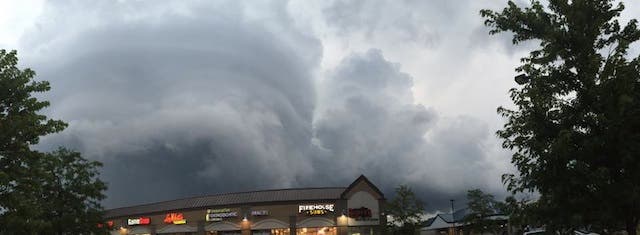
Photo: Tuesday’s super cell that produced dangerous rotating winds near Route 59 and Theodore near Joliet. | Natalia Perez
Illinois storm chasers Danny Neal and Adam Lucio caught, in their words, “wicked, awesome” funnel clouds forming over the Joliet area Tuesday evening.
Neal and Lucio have been chasing and documenting funnel clouds and twisters across the Midwest since 2008. The guys started out around noon Tuesday and drove to Galesburg where they documented storms that formed in Knox County mid-afternoon.
Find out what's happening in Channahon-Minookafor free with the latest updates from Patch.
Illinois storm chasers Danny Neal and Adam Lucio caught, in their words, “wicked, awesome” funnel clouds forming over Channahon and the Joliet area Tuesday evening.
Storm near Joliet and Crest Hill, and Channahon, Tuesday, Aug. 18, 2015. Video by Illinois Storm Chasers
Find out what's happening in Channahon-Minookafor free with the latest updates from Patch.
Storm chase video near Channahon by Illinois Storm Chasers
Neal and Lucio have been chasing and documenting funnel clouds and twisters across the Midwest since 2008. The guys started out around noon Tuesday and drove to Galesburg where they documented storms that formed in Knox County midafternoon.
“We followed those for awhile and made it back to I-55 around 6 p.m.,” Neal said. “We followed the storm from Odell to Channahon, where the storm really got its act together.”
Accompanying the storm chasers on their adventure was a National Weather Service employee. The trio chased a particularly dangerous supercell that developed near Morris and tracked northeast through Channahon, Joliet, Romeoville and on up into Downers Grove.
While chasing the storm, they were phoning in live reports of funnel clouds and rotating air masses to the National Weather Service in Romeoville.
Based on their reports, the Romeoville weather service office issued a tornado warning for the Joliet area around 8:05 p.m.
“Just as the storm got to the weather service office, it tightened up and dropped to the ground,” Neal said, who lives conveniently across the street from the Romeoville National Weather Service office. “To our knowledge we didn’t the tornado on the ground, but we saw strong rotation just aloft. We saw one funnel cloud after another.”
Adds Lucio: “That storm came very close to producing near the Romeoville area. The structure and motion we were watching is the stuff I’ve seen along with some of the strongest tornadoes I’ve documented, so we certainly dodged a bullet today. I believe it was lack of strong surface flow that kept the storm from producing a strong tornado.”
Neal and Lucio shot Tuesday’s video for the Illinois Storm Chaser collaborative.
You can also view their gripping video of massive twisters on the Great Plains at the Northern Illinois Storm Chaser Facebook page.
Get more local news delivered straight to your inbox. Sign up for free Patch newsletters and alerts.