Weather
'Arctic Air', Wind Chills Below Zero Possible Monday In Illinois
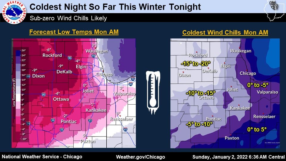
The coldest night this winter is expected Sunday into Monday, the weather service said.

ILLINOIS — After several inches of snow on Saturday and into Sunday, the coldest night so far this winter is expected. Arctic air will move into the Chicago area Sunday night, bringing wind chills below zero, according to the National Weather Service.
Snowfall ended across the area by Sunday afternoon, with the highest snow totals of 6.5 inches in Hoffman Estates, according to the weather service snowfall reports. Other snowfall totals were:
- Oak Park, 5 inches
- Mount Prospect, 4.8 inches
- Schaumburg, 4.7 inches
- O'Hare, 4.1 inches
- Elgin, 4 inches
- Darien, 3.6 inches
- Mokena, 3.5 inches
- Downers Grove, 3.5 inches
Find out what's happening in Chicagofor free with the latest updates from Patch.
Despite the cold, Monday will be dry and sunny, according to the weather service. Tuesday will also be mostly sunny, with a high 35, and with gusts as high as 25 mph.
There is a chance of flurries on Wednesday, which will be mostly cloudy with a high of 27 degrees, the weather service said. Thursday will also have a chance of snow after noon, and will have a high near 14 degrees.
Find out what's happening in Chicagofor free with the latest updates from Patch.
The weather service said another blast of cold air could arrive by early Thursday, and lows around -1 are possible on Thursday night.
Friday will also be quite cold, with a high of 11 degrees and it will be dry and mostly sunny.
Get more local news delivered straight to your inbox. Sign up for free Patch newsletters and alerts.