Weather
Chicago Area Breaks 125-Year Weather Record Monday
Temperatures stretched well into the 60s for northern Illinois on Monday, but cold weather is expected to return soon.

Illinois residents swapped out their snow boots for their sandals on Monday as temperatures neared 70 degrees, breaking a 125-year-old weather record.
Temps climbed into the 60s for Chicago and it suburbs, which is well above the 58-degree record high set for Feb. 16 in Chicago in 1921. As of 3 p.m., the high temperature for the day at O'Hare Airport had reached 62 degrees but other towns in northern Illinois saw temps closer to 70 degrees.
"It feels more like late April than mid-February out there with current temperatures in the low- to mid-60s," the National Weather Service reported just before 1 p.m. Monday.
Find out what's happening in Chicagofor free with the latest updates from Patch.
It feels more like late April than mid February out there with current temperatures in the low to mid 60s. Daily high temperature records have already fallen at both Rockford and Chicago. Enjoy the warmth, everyone! #ILwx #INwx pic.twitter.com/UtE3zlmjyL
— NWS Chicago (@NWSChicago) February 16, 2026
The comfortable temps come after the Chicago area rarely saw temperatures reach above freezing but they are not expected to last for long. The spring-like warmth is expected through Thursday but Friday, winter is expected to return with the possibility of a rain and snow mix for portions of the Chicago area.
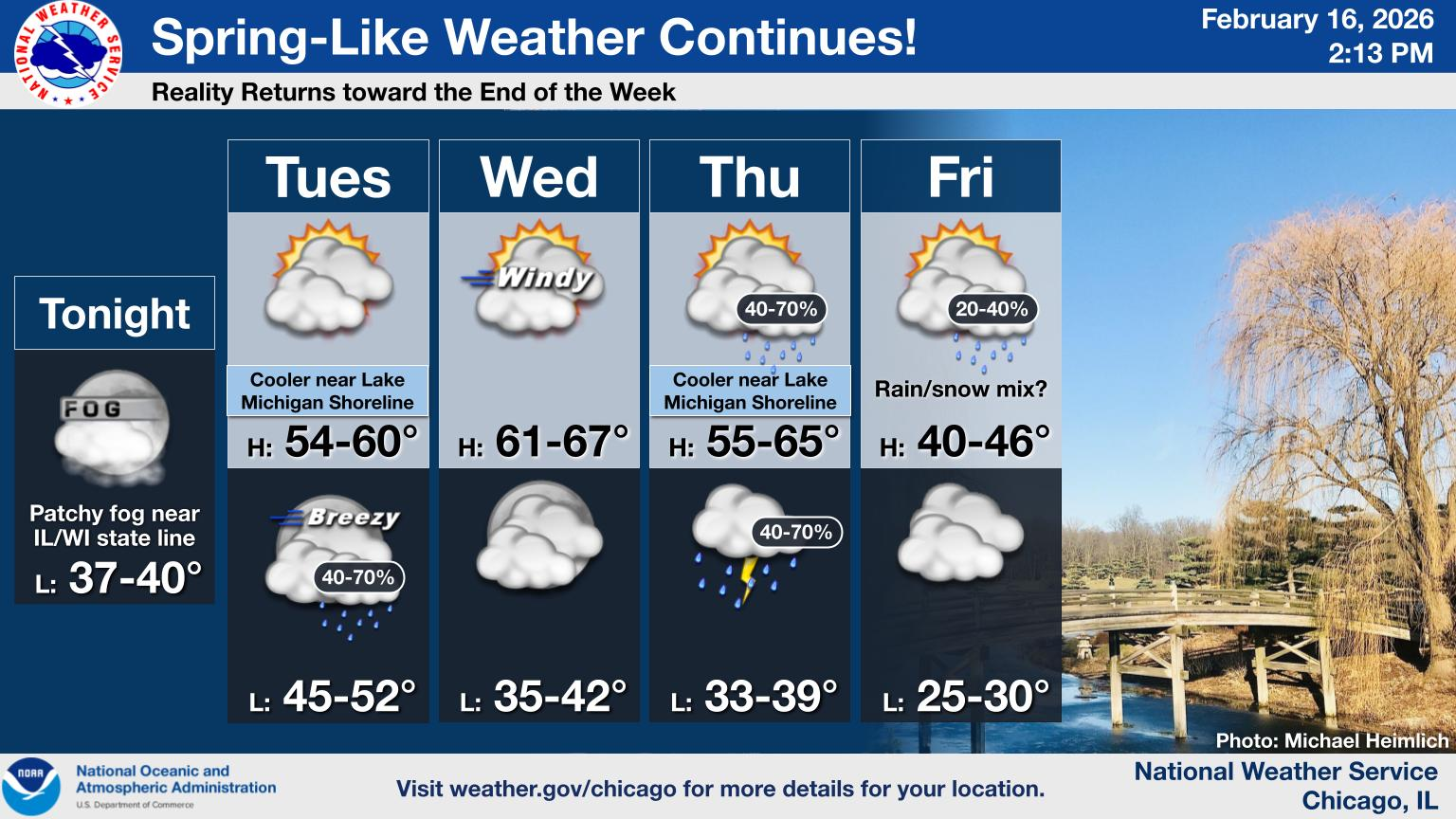
And next weekend, highs in the 30s are expected again for the Chicago area. Here is a closer look at the forecast for the coming week:
Find out what's happening in Chicagofor free with the latest updates from Patch.
- Monday night: Patchy fog after midnight. Otherwise, partly cloudy, with a low around 40. Southwest wind 5 to 10 mph becoming south southeast after midnight. Winds could gust as high as 15 mph.
- Tuesday: A 20 percent chance of rain after 5pm. Patchy fog before 9am. Otherwise, mostly cloudy, with a high near 50. Southeast wind 5 to 15 mph, with gusts as high as 20 mph.
- Tuesday night: A chance of rain, then rain and possibly a thunderstorm after midnight. Low around 48. Southeast wind around 15 mph becoming south southwest after midnight. Winds could gust as high as 25 mph. Chance of precipitation is 80%. New rainfall amounts between a tenth and quarter of an inch, except higher amounts possible in thunderstorms.
- Wednesday: Partly sunny, then gradually becoming sunny, with a high near 63. Breezy, with a west southwest wind 15 to 20 mph, with gusts as high as 30 mph.
- Wednesday night: Mostly cloudy, with a low around 40. West southwest wind 5 to 10 mph becoming southeast after midnight.
- Thursday: A 40 percent chance of rain after noon. Partly sunny, with a high near 48.
- Thursday night: Rain, mainly before midnight. Low around 37. Chance of precipitation is 80%.
- Friday: A chance of rain before noon, then a chance of rain and snow. Partly sunny, with a high near 44.
- Friday night: Mostly cloudy, with a low around 30.
- Saturday: Partly sunny, with a high near 38.
- Saturday night: Mostly cloudy, with a low around 27.
- Sunday: Partly sunny, with a high near 34.
- Sunday Night: Partly cloudy, with a low around 22.
- Monday: Partly sunny, with a high near 33.
Get more local news delivered straight to your inbox. Sign up for free Patch newsletters and alerts.