Weather
Chicago-Area Weather: Flooding Continues / Heat and Humidity Is Coming / Dangerous Swim Conditions
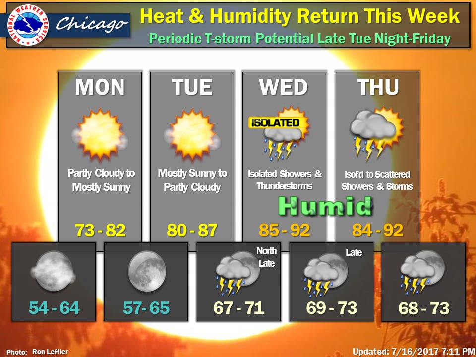
A look at this week's weather forecast for the Chicago area.


It's been a rough week for many towns in the northwest suburbs where strong storms on Tuesday and Wednesday brought heavy rains, causing severe flooding. Flooding woes continued through the weekend and a flood warning remains in effect for the Des Plaines River near Russell, Gurnee, Lincolnshire, Des Plaines and Riverside and for the Fox River at the Algonquin Tailwater and in Montgomery. For towns along the Des Plaines River, floodwaters appear to have crested at this point, according to the National Weather Service, but the Fox River in Algonquin is expected to rise through Tuesday morning.
As of Sunday evening, the Fox River in Algonquin had reached 12.24 feet. The river's flood stage in Algonquin is 9.5 feet. Weather officials expect the river to rise to 12.7 feet by 7 a.m. on Tuesday before beginning to fall. Areas near the Fox River at the McHenry Dam in McHenry are also experiencing flooding. The river reached 7.34 feet -- well above its flood stage of four feet -- Sunday evening.
Lake County has also been hard hit by floods in the past week. Gov. Bruce Rauner in recent days declared Kane, McHenry and Lake counties disaster areas and was in Algonquin on Sunday to survey damage and hold a press conference. More information on the current river levels along the Des Plaines River, and other rivers across the Chicago area, can be found here.
Find out what's happening in Chicagofor free with the latest updates from Patch.
Officials continue to urge anyone who encounters a flooded roadway to turn around and not enter floodwaters. For more Patch coverage on the recent flooding, visit here.
The week ahead is expected to be dry through mid-week. Monday and Tuesday should be the most comfortable, temperature-wise, but the heat and humidity is expected to by Wednesday. Isolated showers and thunderstorms are also in the forecast for Wednesday and Thursday.
Find out what's happening in Chicagofor free with the latest updates from Patch.
Meanwhile, on Sunday, a beach hazards statement was issued for Illinois beaches along Lake Michigan as well as beaches along the lake in Northwest Indiana. Wave heights of four to seven feet were in the forecast and strong rip currents and structural currents are expected. People visiting the beaches should stay out of the water. For the latest on the beach forecast for beaches along Lake Michigan, visit here.
Here is a more detailed look at the forecast for the week ahead:
- Sunday Night: Clear. Lows in the mid 50s in the suburbs... but in the lower 60s downtown. North winds 10 to 15 mph.
- Monday: Partly cloudy in the morning then clearing. Highs in the upper 70s inland...but only in the mid 70s near the lake. Northeast winds 5 to 10 mph.
- Monday Night: Clear. Lows around 60 in the suburbs...but in the mid 60s downtown. East winds 5 to 10 mph in the evening becoming southeast after midnight.
- Tuesday: Mostly sunny. Highs in the mid 80s. South winds 5 to 10 mph.
- Tuesday Night: Mostly clear in the evening then becoming partly cloudy. Lows in the upper 60s. South winds 5 to 10 mph.
- Wednesday: Partly cloudy with a 30 percent chance of showers and thunderstorms. Highs in the upper 80s.
- Wednesday Night: Partly cloudy with a 30 percent chance of showers and thunderstorms. Lows in the lower 70s.
- Thursday: Partly sunny with a 40 percent chance of showers and thunderstorms. Highs in the upper 80s.
- Thursday Night: Partly cloudy with a 40 percent chance of showers and thunderstorms. Lows in the lower 70s.
- Friday Through Saturday: Partly cloudy with a 30 percent chance of showers and thunderstorms. Highs in the mid 80s. Lows in the lower 70s.
Get more local news delivered straight to your inbox. Sign up for free Patch newsletters and alerts.