Weather
Chicago-Area Weather: The Heat Continues
A look at the weather forecast for the Chicago area for the coming days.


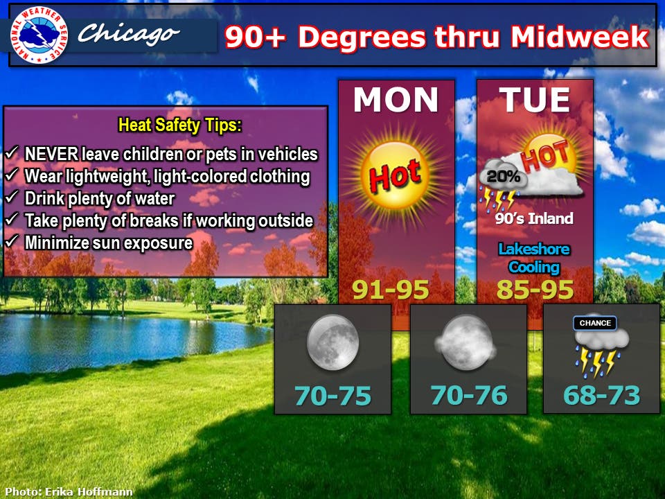
The extreme heat that hit the Chicago area this weekend is expected to continue in the coming days. It's going to be muggy on Monday and Tuesday with high temps reaching into the 90s and heat index values pushing toward the 100-degree mark, especially on Tuesday, according to the National Weather Service. On Monday, high temps are expected to reach between 91 and 95 degrees while Tuesday could see highs between 85 and 95 degrees with cooler temps expected along Lake Michigan.
Winds will remain somewhat breezy over the next couple days but it's not expected to be as windy as it was this past weekend, according to the National Weather Service. More than likely, the area will remain dry again on Monday with plenty of sunshine. There is a 20 to 30 percent chance some areas could see a thunderstorm on Tuesday.
Better chances for precipitation arrive Wednesday and Wednesday night.
Find out what's happening in Chicagofor free with the latest updates from Patch.
Here is a more detailed look at the forecast for the coming days:
- SUNDAY NIGHT: Clear. Lows in the lower 70s. Southwest winds 10 to 20 mph. Gusts up to 30 mph in the evening.
- MONDAY: Mostly sunny. Continued hot. Highs in the lower 90s. Southwest winds 10 to 15 mph.
- MONDAY NIGHT: Mostly clear. Lows in the mid 70s. Southwest winds 5 to 10 mph.
- TUESDAY: Partly sunny with a 30 percent chance of showers and thunderstorms. Highs in the lower 90s inland...but only in the upper 80s near the lake. South winds 10 to 15 mph.
- TUESDAY NIGHT: Partly cloudy with a 30 percent chance of showers and thunderstorms. Lows in the lower 70s. South winds 5 to 10 mph.
- WEDNESDAY: Partly sunny with a 40 percent chance of showers and thunderstorms. Highs in the upper 80s.
- WEDNESDAY NIGHT: Mostly cloudy with a 50 percent chance of showers and thunderstorms. Lows in the upper 60s.
- THURSDAY: Partly cloudy. Highs in the upper 80s.
- THURSDAY NIGHT: Mostly clear. Lows in the upper 60s.
- FRIDAY: Partly cloudy with a 40 percent chance of showers and thunderstorms. Highs in the upper 80s inland...but only in the lower 80s near the lake.
- FRIDAY NIGHT: Partly cloudy. A 30 percent chance of showers and thunderstorms after midnight. Lows in the upper 60s.
Chicago Area Could See Rare 4-Day Stretch of 90-Degree Temps
The early season heat the Chicago area is experiencing should bring a three- or four-day stretch of temperatures in the 90s. High temp hit 90 degrees on Saturday and 92 degrees at Chicago's O'Hare International Airport.
Find out what's happening in Chicagofor free with the latest updates from Patch.
A four-day stretch of this kind of heat is very rare prior to the midpoint of June, according to the National Weather Service. Since 1972, there have only been nine years that have tallied four or more days of 90-degree temps during this time frame.
The most recent was 18 years ago on June 8 through June 11, 1999. The earliest on record was May 3 through May 6, 1949, while the longest early season stretch was nine days from May 16 to May 24, 1977.
Early season stretches of just three consecutive 90-degree days are much more common. The most recent was June 9 through June 11, 2012.
In the average summer, the Chicago area will see 14 days with weather over the 90-degree mark. Along the lakefront, there is typically eight days that see that kind of heat.
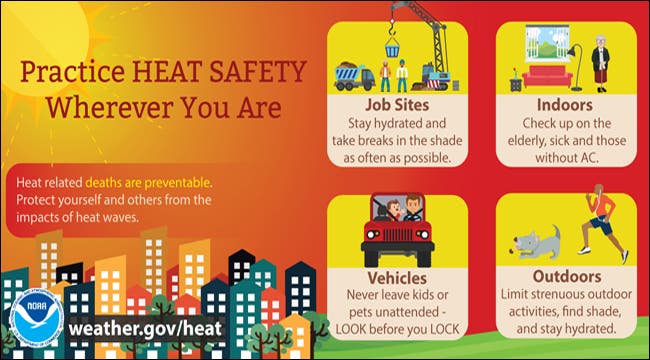
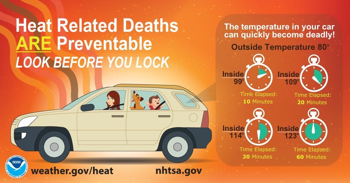
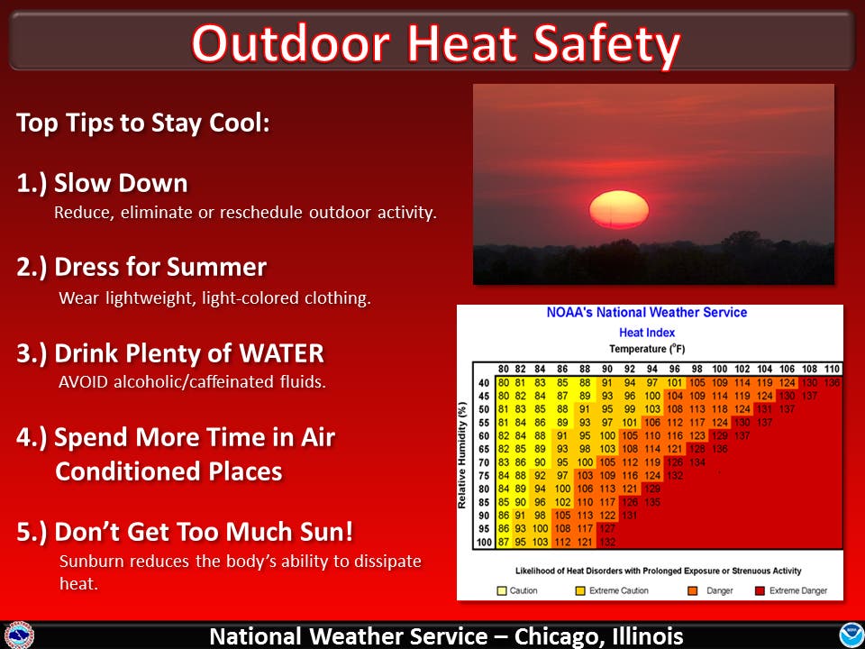
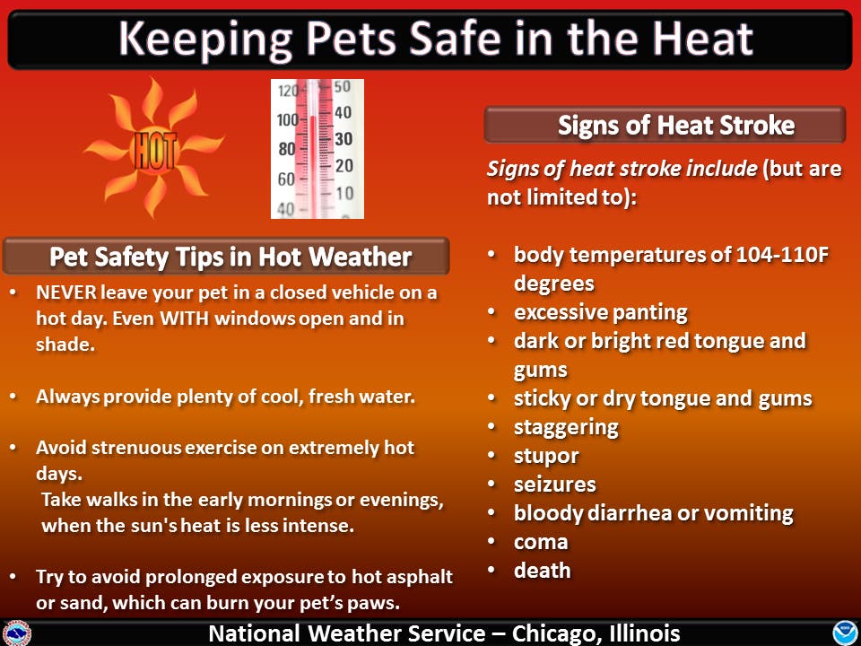
Heat Safety Tips
Area residents are reminded to stay safe during the extreme heat. The National Weather Service provides the following tips for keeping you, your kids and your pets safe in the coming days.
Get more local news delivered straight to your inbox. Sign up for free Patch newsletters and alerts.