Weather
Chicago-Area Weather: Severe Storms Possible Monday; Hot, Humid Week Ahead
A look at the weather forecast for the upcoming week for the Chicago area.


Strong storms early Monday morning could bring 70 mph wind gusts, quarter-sized hail and flooding to the Chicago area. The National Weather Service is predicting severe storms could hit between 1 and 7 a.m. on Monday. Weather officials are urging area residents to have multiple ways to receive weather warnings.
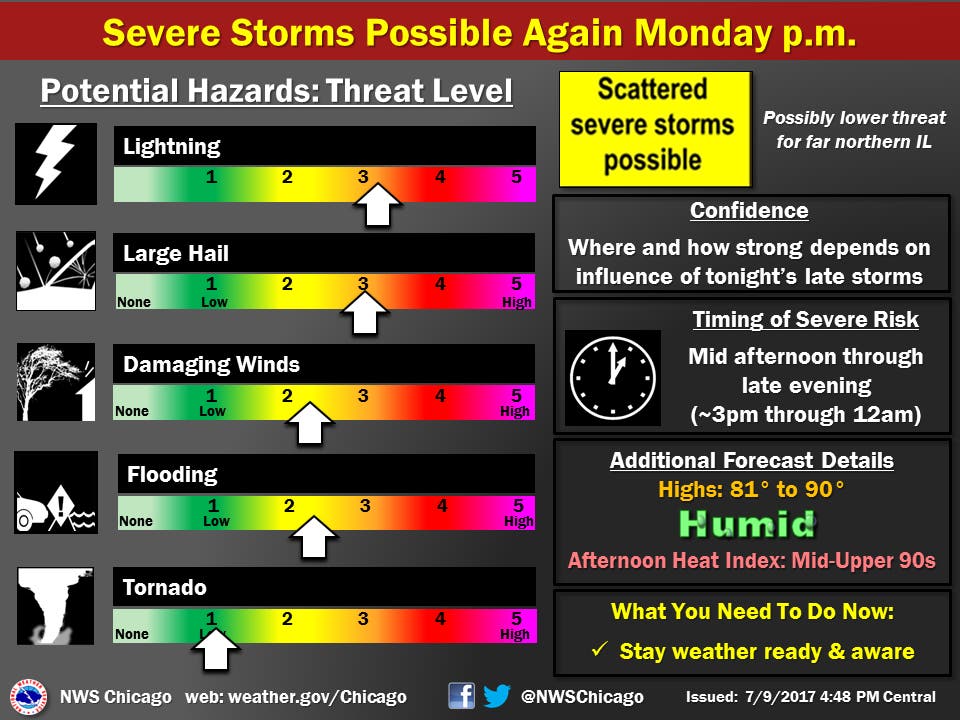
On Monday, expect hot and humid weather. The Chicago area should see high temps between 81 and 90 degrees with heat index values reaching into the mid- to upper-90s. Severe thunderstorms are also expected Monday afternoon and could continue into Monday night.
Those storms could bring large hail, lightning, damaging winds, flooding and a tornado, according to the National Weather Service.
Find out what's happening in Chicagofor free with the latest updates from Patch.
The most intense thunderstorms over the next day could bring torrential downpours, which could lead to flooding. Area residents living along rivers or in flood-prone area are urged to be prepared for possible flooding.
More storms are possible Tuesday, Thursday and this weekend and high temps are expected to be in the 80s and 90s for much of the Chicago area this week.
Find out what's happening in Chicagofor free with the latest updates from Patch.
Here is a more detailed look at the forecast for the week ahead:
- SUNDAY NIGHT: Partly cloudy this evening then becoming cloudy. slight chance of showers and thunderstorm from mid evening through early overnight, then showers and thunderstorms after 3 am. Lows around 70. South winds 5 to 10 mph. Chance of precipitation 80 percent.
- MONDAY: Mostly cloudy. Showers and thunderstorms likely in the early morning, then a chance of showers and thunderstorms. Highs in the mid 80s. Southwest winds 10 to 15 mph. Chance of precipitation 60 percent.
- MONDAY NIGHT: Mostly cloudy with a 40 percent chance of showers and thunderstorms. Lows in the upper 60s. North winds 10 to 15 mph.
- TUESDAY: Partly sunny. A 20 percent chance of showers and thunderstorms in the afternoon. Highs in the lower 80s inland... But only in the upper 70s near the lake. North winds 5 to 10 mph in the morning becoming northeast in the afternoon.
- TUESDAY NIGHT: Mostly cloudy. Chance of showers and thunderstorms in the evening, then showers and thunderstorms likely after midnight. Lows in the lower 70s. East winds 5 to 10 mph in the evening shifting to the south 10 to 15 mph after midnight. Chance of precipitation 60 percent.
- WEDNESDAY: Partly sunny with a 40 percent chance of showers and thunderstorms. Highs around 90.
- WEDNESDAY NIGHT: Partly cloudy. A 40 percent chance of showers and thunderstorms in the evening. Lows in the lower 70s.
- THURSDAY: Partly sunny. Highs in the lower 80s inland...but only in the upper 70s near the lake.
- THURSDAY NIGHT THROUGH FRIDAY NIGHT: Partly cloudy. Lows in the mid 60s. Highs in the lower 80s.
ENTER TO WIN: Patch's Chicago-Style Who Makes The Best Pizza Contest
Get more local news delivered straight to your inbox. Sign up for free Patch newsletters and alerts.