Weather
6 Inches Of Snow Possible In Illinois New Year's Day Winter Storm
Winter storm watch: Blowing snow, wind gusts up to 40 mph possible during New Year's Day snowstorm.

ILLINOIS — A New Year's Day winter storm could bring more than 6 inches of snow to the Chicago area, according to the National Weather Service. Winter storm watches are in effect Saturday morning through Saturday night:
- Northern, eastern and southern Will, Grundy, Kane, Kendall and McHenry counties: Snow in excess of 6 inches, wind gusts over 35 mph and blowing snow, creating dangerous travel.
- Central, northern and southern Cook, DuPage and Lake counties: Snow accumulations of more than 6 inches and wind gusts in excess of 40 mph, with steady blowing snow and dangerous driving conditions.
The weather service said chances continue to increase for a significant winter storm to hit the area, with the most significant snowfall likely coming Saturday afternoon and Saturday night.
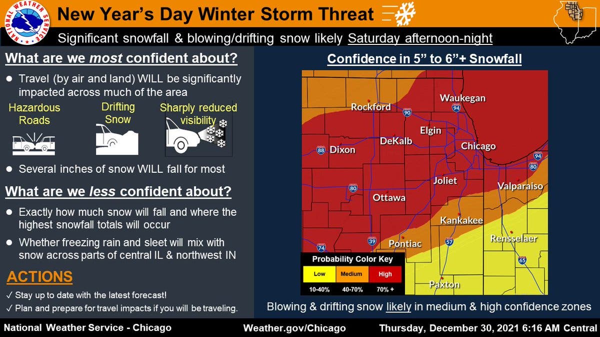
Several inches of snow will fall for most of the area, the weather service said. The weather service is less confident on how much snow will fall and where the highest snowfall totals will occur.
Find out what's happening in Chicagofor free with the latest updates from Patch.
For the Joliet, Chicago, Elgin and Waukegan areas, there is a high confidence in 5 to 6-plus inches of snow, according to the weather service. The Kankakee and Rockford areas have a medium confidence of 5 to 6-plus inches of snow.
Thursday night expected to be foggy, with potentially dense fog across parts of northern Illinois lasting into Friday morning, starting with patchy fog after 10 p.m. As for New Year's Eve, Friday night looks to be cloudy, with a low of 31 degrees and a slight chance of rain and snow after midnight.
Find out what's happening in Chicagofor free with the latest updates from Patch.
New Year's Day travel may become very hazardous due to snow-covered roads and low visibility, according to the weather service. Anyone planning to travel should stay up to date on the forecast.
After the snow on Saturday, cold air will also shift over the area on Sunday, the weather service said. Wind chills of minus 5 to minus 20 are possible Sunday night and into early Monday with the cold air.
Get more local news delivered straight to your inbox. Sign up for free Patch newsletters and alerts.

