Weather
20 Inches Of Snow In IL? Not Likely Despite Models, NWS Says
Some models were showing more than a foot of snow hitting IL, but depending on where you live, you could see no snow or more than 8 inches.

ILLINOIS — It was nearly January before snow finally hit the Chicago area and now, not one, but two major winter storms could hit this week, according to the National Weather Service. But despite some early models showing more than a foot of snow in some areas — and more than 20 inches in others — the National Weather Service is being much more conservative with its snowfall estimates.
"In all, the chance for more than 8" of snow continues to rise, especially along/SE of I-55," NWS said. "Note that raw model snowfall outputs are likely too high, since they ignore compaction during and between the waves of snow." But, the weather service warned residents: "Be prepared and stay up to date on the forecast."
Depending on where you live in the Chicago area, you may see little to no snow or more than 8 inches of snow, according to the NWS forecast.
Find out what's happening in Chicagofor free with the latest updates from Patch.
The weather service has issued winter storm watches for Grundy, Kankakee, Livingston, central and southern Cook county, as well as Will County. The watch is in effect from Tuesday evening through Thursday afternoon.
The weather service said heavy snow and dangerous travel conditions are possible during this time, and total snow accumulations in excess of 6 inches are possible.
Find out what's happening in Chicagofor free with the latest updates from Patch.
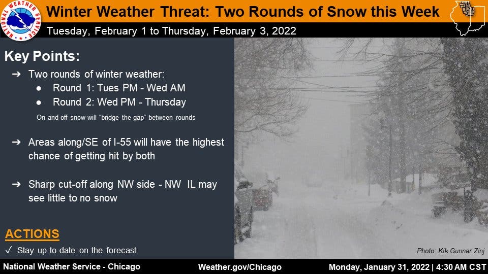
The first round of snow will begin Tuesday night through Wednesday morning, and the second round will be Wednesday night through Thursday, according to the weather service.
Areas along and southeast of Interstate 55 will have the highest chance of getting hit by both rounds of winter weather, the weather service said. The chance for more than 8 inches of snow in that area continues to rise, according to the weather service. There will be a sharp cut-off in snow totals along the northwest side of the storm, and northwest Illinois may see little to no snow.
According to the weather service, rain will change to snow after sunset on Tuesday, with a low probability of winter weather for the Waukegan and Elgin areas; a medium probability for the Chicago and Joliet areas; and a high probability for Kankakee.
The second round of snow will have the heaviest snow rates from midnight to early afternoon on Thursday, the weather service said. The Waukegan, Elgin and Chicago areas have a medium probability of winter weather, Joliet is on the edge of medium and high probability of winter weather, and Kankakee once again has a high probability.
Shoveling safety
Heavy snowfall can mean increased heart attack risk as residents dig out. According to the American Heart Association, before you pick up that shovel, you should:
- Avoid eating a heavy meal.
- Avoid alcohol.
- Use a small shovel, as lifting heavy snow can increase blood pressure.
- Learn the dangers of hypothermia and dress in layers.
- Know the signs of a heart attack: Chest discomfort, pain in the arm, neck or jaw; cold sweat; nausea; and shortness of breath. Stop immediately and seek medical help if you notice any of these symptoms.
Police also reminded residents to help firefighters by clearing a three-foot radius around fire hydrants.
Get more local news delivered straight to your inbox. Sign up for free Patch newsletters and alerts.

