Weather
Still No Measurable Snow For IL? Light Snow Before Dry Weekend
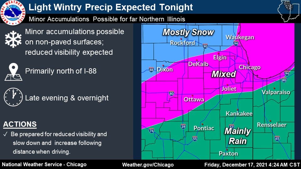
Minor accumulations are possible on non-paved surfaces late Friday and overnight, the weather service said.

ILLINOIS — Light wintry precipitation is expected Friday night, with minor snow accumulations possible, according to the National Weather Service.
The weather service said minor accumulations of snow are possible primarily north of Interstate 88 late Friday and overnight into Saturday. Areas near Chicago, Elgin and Joliet will most likely see mixed precipitation and the Kankakee area will see mainly rain.
The precipitation will transition to drizzle and flurries while temps in the mid-30s are expected on Saturday, the weather service said. Temps through the weekend and into next week will be seasonable for this time of year.
Find out what's happening in Chicagofor free with the latest updates from Patch.
Saturday will have a high of 38 degrees, and Sunday a high of 36, according to the weather service.
Sunday and the start of the work week look to be mostly sunny, according to the weather service.
Find out what's happening in Chicagofor free with the latest updates from Patch.
Friday night's precipitation could prevent the breaking of the record for latest measurable snowfall, according to the weather service. Currently, the record for latest measurable snowfall at O'Hare is Dec. 20.
Get more local news delivered straight to your inbox. Sign up for free Patch newsletters and alerts.

