Weather
5 Inches Of Snow Possible Before Bitter Cold Moves In: IL Weather
Snow will begin between 3 and 6 p.m. Wednesday for the Joliet, Chicago and Elgin areas, and between 6 and 9 p.m. for the Waukegan area.

ILLINOIS — Snow is on the way for the Chicago area, especially south of Chicago. A winter weather advisory has been issued for Grundy, Will, Kankakee, Livingston, Iroquois, Ford, Newton, Jasper and Benton counties from 2 p.m. Wednesday until noon Thursday.
The National Weather Service said total snow accumulations of 2 to 5 inches are expected. Snow could impact the Wednesday evening and Thursday morning commutes.
Snow, possibly mixed with rain at first, will spread across the area from south to the north starting Wednesday afternoon. The weather service said the snow will continue Wednesday night into Thursday with a possibility of pockets of blowing snow after midnight.
Find out what's happening in Lemontfor free with the latest updates from Patch.
According to the weather service, snow will begin between 3 and 6 p.m. Wednesday for the Joliet, Chicago and Elgin areas; and between 6 and 9 p.m. for the Waukegan area.
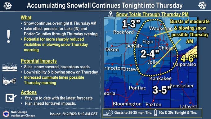
After snow ends Thursday, some bitterly cold temperatures are in the forecast. Wind chills will dip to 10 or 20 below zero. A high of 17 degrees is expected Friday, the weather service said.
Find out what's happening in Lemontfor free with the latest updates from Patch.
Get more local news delivered straight to your inbox. Sign up for free Patch newsletters and alerts.

