Weather
5 Inches Of Snow: When Snowstorm Will Start In Illinois
The heaviest snowfall rates, of at least a half-inch per hour, are expected late Wednesday afternoon and evening.


ILLINOIS — A snowstorm is expected to move into the area Wednesday, and winter weather advisories have been issued for the far south suburbs, which are expected to get the most accumulation. A winter weather advisory is set for Kankakee, Livingston, Ford and Iroquois counties from 3 p.m. Wednesday to noon Thursday.
Snow will start between 5 and 7 p.m. for the Chicago and Joliet areas and between 6 and 9 p.m. for the Elgin and Waukegan areas, the National Weather Service said.
Related Articles:
Find out what's happening in Lemontfor free with the latest updates from Patch.
- Stay Warm On The Go With These Handy Cold Weather Essentials
- Clever Ways To Keep Your House Warm Without Cranking Up The Heat
- Cold Weather Skincare Tips From A Dermatologist
The heaviest snowfall rates, possibly in excess of a half-inch per hour, are expected late Wednesday afternoon and evening, the weather service said. Higher rates of snow are possible along and southeast of Interstate 55.
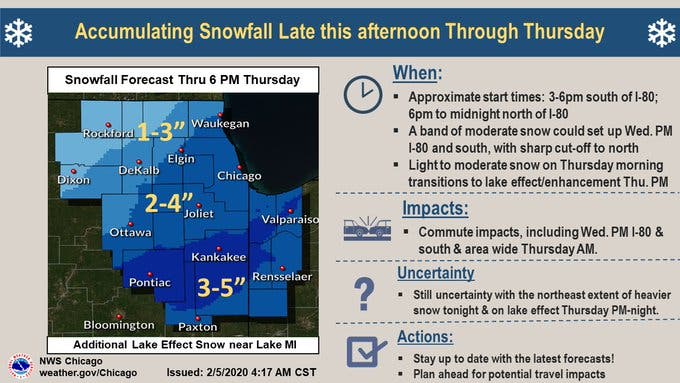
Most of the area will receive between 2 and 4 inches of snow, according to the weather service. The far north suburbs will have less accumulation, while the far south suburbs will have more.
Find out what's happening in Lemontfor free with the latest updates from Patch.
The weather service said commutes could be impacted, including during Wednesday evening and Thursday morning.
Get more local news delivered straight to your inbox. Sign up for free Patch newsletters and alerts.